skip to main |
skip to sidebar
One of my favorite things to do is going places I've never been before. I love filling in places on the map with real time adventure.
So I jumped at a recent invite to road trip to Rossland, a charming historic mining town turned outdoors mecca in the famous Kootenay Rockies Region of British Columbia, Canada. While our goal was skiing at Red Mountain, first I have to tell you about the great road trip there from Seattle.
When people outside the Pacific Northwest think of Washington, they usually think hipster-ish Seattle, coffee, rain, deep green forests, and the sea. Of course our region is much more varied and dramatically different east of the Cascade Crest.
I pulled out my dog-eared copy of Roadside Geology of Washington to learn more about the country we passed through. Some 200 million
years ago, much of what became Washington consisted of two large islands drifting in the Pacific
Ocean. One after the other they "docked" onto the west coast of the North American
continent, which was once almost as far east as Idaho.
From the edge of Puget Sound to Wenatchee on US Route 2 (the Stevens Pass Scenic Byway), we traversed the ancient North Cascades subcontinent. This micro-continent was one of the former islands that collided and merged into what is today the western edge of the Columbia River Plateau.
 |
| The former "west coast" |
We snuck over to Leavenworth Thursday pm to get a head start on the long drive to Rossland the next day (with a few planned stops). A dusky pink alpenglow hovered over the mountains surrounding town as we arose early Friday, a good harbinger for the day ahead.
As we drove southeast towards Wenatchee, the sun was still below the surrounding mountains. After turning northward onto Route 97 along the Columbia River toward Chelan (our first stop), the sunlight was just cresting the hilltops along the river.
This much more arid country east of the Cascades is characterized by rolling hills, rocky outcrops, and sparse vegetation. I call it the "dry side."
After a quick stop in Chelan for an errand and to grab a hot drink, we dropped back down to the river and continued northward. The town of Chelan lies at the edge of the glacial moraine formed by the receding glacier thousands of years ago that scoured what became Lake Chelan. [Interesting factoid: The bottom of Lake Chelan is lower than sea level.]
 |
| Lake Chelan |
We followed the Columbia River, which is dammed into a series of submissive "lakes" along this route, until it drifted eastward toward Grand Coulee Dam and we continued north.
After leaving the river behind, we passed through the thoroughly eastern Washington small towns of Okanogan, Omak, and Tonasket. We're definitely not in Seattle anymore Toto.
 |
| Downtown Tonasket |
A quick shout-out to Shannon's Deli & Cafe in Tonasket, where we stopped for a breakfast sandwich on the way to B.C. and for a slice of not too tart, not too sweet, just right berry pie on the way home.
And for you geology geeks, Tonasket marks the southern edge and west coast of the former Okanogan island continent (comparable to the North Cascades subcontinent) that also docked against North America about 100 million years ago.
At Tonasket we turned right (eastward) on Highway 20 and enjoyed beautiful, snowy, mountainous scenery as the highway angled northeast towards the town of Republic. There's not much out here but lovely scenery and scattered ranches and homes (see the shot at the top of this post).
These remote mountains of northeastern Washington are home to most of the wolf packs that have returned to our state the last decade or so.
After a stop in Republic for provisions (snacks, a map), we turned north past Curlew and on up to the border crossing at Danville. Several deer were trudging through the snow along the Kettle River as we passed by.
 |
| Downtown Republic |
Grand Forks, BC, just across the US border, was our destination for a few hours in the afternoon to visit family. This small town, among many others in this part of BC, is becoming a landing spot for refugees escaping the expensive cost of living around Vancouver on the coast.
In Grand Forks, we enjoyed excellent coffee and tea at Kocomo's, owned by a friendly mother and son duo.
From Grand Forks on to Rossland, we drove another 80 minutes through the mountains to Rossland and Red Mountain.
What is your favorite road trip around the Northwest, or anywhere? Would love to hear in a comment below.
Happy trails and thanks for visiting Pacific Northwest Seasons!
In between blog posts, visit Pacific NW Seasons on FaceBook, Twitter, and Instagram for more Northwest photos and outdoors news.
When You Go
Our total driving time from Seattle to Rossland was between 8 and 9 hours, factoring in stops along the way. We opted to drive north and go over Highway 2 instead of I-90 for an overnight in Leavenworth en route, then north on Highway 97 near Wenatchee, then east onto Highway 20 at Tonasket, then north onto Highway 21 just past Republic to the Danville border crossing, then east-northeast on Highway 3 past Grand Forks, then south onto Highway 38 to Rossland. Sorry, all the routes I searched for online don't show this exact route. Here's a map showing the region and a fairly close route that travels farther east before cutting north.
Have you gotten outside much this winter?
Here in Upper Left USA, winter has been throwing us lots of rain, snow, and sun, so I've gotten good use of my rain and cold weather gear. Some hiking, some skiing, a getaway, it all has been fun between bouts of working overtime.
So today's post is a mélange of adventures around Washington since the first of the year.
Hiking in the Rain
When a pineapple express hit in January, plans to go skiing one Saturday morphed into a hike up Boulder River off the Mountain Loop Highway near Darrington, Washington.
Heavy rain was predicted, which makes for good waterfall viewing. Plus it's more comfortable hiking in the rain than skiing in the rain. (Umbrellas can be your friend, but not on the slopes.)
We were lucky, the rain didn't really start up in earnest until shortly before we arrived back at the car after a 7.5-mile hike. And yes, the waterfalls and the mossy green woods along the river were gorgeous.
This trail is fairly easy, with a gain of less than 1,000 feet (gotta get your heart rate up a bit). It's also very popular, even on this rainy day the parking lot was full and then some.
After Hike Eats
My friend Andy directed us to the Stilly Coffee House in Arlington on the way home, where we refueled with fresh cookies and hot drinks after a chilly, damp hike. I like supporting independent small businesses, and the Stilly was warm and friendly. (BTW Stilly is the nickname for the Stillaguamish River that flows through Arlington.)
Heading East to Ski
Early February we headed over to Leavenworth, Washington, for a few nights to catch up with some friends and ski Mission Ridge above Wenatchee. After the warm spell, there was a fast snowmelt around Leavenworth, leaving snow levels comparable to late March instead of early Feb.
But the brilliant blue skies were worth the trip.
We drove up to Mission Saturday, where the snow was mostly hard and a bit icy (they've since gotten more snow). For several runs I skied with a guy who knew the area well and took me on a some fun runs I wouldn't have found easily. Mission features friendly locals and smooth groomer runs.
The contrast between the mountain and the arid, dry land beyond is striking and so different than skiing on the west side of the Cascade Crest. Plus the views the other direction from the top of the ridge are lovely too, with Mt. Rainier dominant on the southern horizon.
After Ski Eats
Afterwards we met up with a friend down near the Columbia River in Wenatchee at the Pybus Public Market. We snacked at the Cafe Columbia, where I had a very tasty spiced cookie, but there are numerous other options at this indoor market—
a great addition to the Wenatchee food scene.
Hiking Leavenworth
After a great dinner Saturday night at Kingfisher Restaurant at Sleeping Lady Resort, the next morning we awoke to more bluebird skies. Normally we'd do some cross-country skiing, but instead the trail was clear enough to hike up the Icicle Ridge Trail above Leavenworth.
While I'm an enthusiast for hiking in the rain, I must admit it was wonderful to be hiking in the sunshine again.
Skiing the Pass
To Northwesterners, "the Pass" could be several places. To Puget Sound dwellers, it might be Stevens Pass or Snoqualmie Pass, but on President's Day for us it was Snoqualmie.
While the "real" skiing around these parts is at Crystal Mountain or Stevens, for a quick morning of fun turns, Snoqualmie is just fine. We arrived before the lifts opened to get a close parking space (Silver Fir Lodge is the way to go), and then skied the crossover to Summit East, which I will always call Hyak.
A morning of cold snowy bliss ensued. While we take Snoqualmie for granted, it really is quite scenic up there.
So there you have it. Just a smattering of outdoors activities around western Washington this winter. Oh, and today I just skied my best powder day ever at Crystal Mountain. Too cold and snowy for action photos!
How about you? Where have you gotten outdoors the last few months?
Happy trails and thanks for visiting Pacific Northwest Seasons!
In between blog posts, visit Pacific NW Seasons on FaceBook, Twitter, and Instagram for more Northwest photos and outdoors news.
Here in the Pacific Northwest, winters are long and damp, days are short, and dark gray skies often rule.
Although it's still a good time to get outside, a winter getaway to somewhere warm and tropical is something we Northwesterners often indulge in. You'll find plenty of us over in Hawaii this time of year.
While I've been to Oahu, Maui, and the Big Island of Hawaii a few times, a couple friends and I jetted to Kauai recently, my first time there.
Boasting some of the heaviest rainfall on the planet, Kauai didn't disappoint when we were there. One day it rained so hard roads were closed in some areas. But I think falling asleep during a warm tropical downpour is just about the best sleeping weather. During my week there, I slept better and longer than I have for months, maybe years.
True to the spirit of this blog, it was a pretty active vacation, with several hikes I'll tell you about.
Waimea Canyon/Pihea Trail
With a 3-hour time difference, we were up and out early our first morning for the winding mountain road drive up to Waimea Canyon area to explore and hike. We stopped at several overlooks for some shots; the canyon really is as spectacular as the many photos I've seen.
At the very end of the road, as far as you can drive on the northwest side of the island is the Pihea Trail. This relatively short trail (about 4 miles out and back) is not in very good condition due to extensive overuse.
It was rough, rutted, full of gnarled roots, and of course muddy. We turned around before the final push because it got so bad, but not before we got some spectacular views of beautiful Kalalau Valley just a few hundred yards down the trail. Here's hoping that some trail maintenance/restoration work will be done there soon (they could use some WTA volunteers).
On the way back we stopped in the coastal town of Waimea and had the first of several marvelous fresh mango banana smoothies. (Didn't get the name of the place but it's next to the Shrimp Station.) Fresh tropical fruit in the tropics is the best!
Awaawapuhi Trail
From Poi'pu, the next day we went back up to the Waimea Canyon area and hiked the longer Awaawapuhi Trail (about 6.5 miles RT). With an early start, we headed down the trail from elevation 4,120 feet through a tropical jungle down to a narrow ridge with stunning views of the Na Pali coast, at elevation 2,500 feet.
For those of you with any fear of heights (hand up in the air here), don't venture all the way out to the very narrow rock bridge to the small rock promontory beyond. I started to cross it, but just couldn't. Signs warn hikers to not go beyond the railings anyway.
Watch your step because it's easy to misjudge, and there have been fatalities here. (Check out HuffPost if you want to see one of the scariest selfie videos ever at this trail.) But the views of the otherworldly cliffs are magnificent.
Mahaulepu Heritage Coastal Trail
On the popular and increasingly developed south shore of Kauai, the Mahaulepa Heritage Coastal Trail is an easy but lovely hike along the only accessible undeveloped stretch of coastline. Our third day here, we literally walked from our ocean-view condo past resorts and a golf course in the Poi'pu area to this coastline trail.
As you can see in the shot above, tropical rain squalls were threatening, and we ultimately did get caught in a soaker. But it was refreshing on a hot afternoon.
After the first quarter mile, we had this lovely trail along the coast pretty much to ourselves. Surprising since we just left a dense cluster of resorts and condos.
This easy trail (a bit of scrambling over rocks can be involved) is only 4 miles roundtrip. As always, generous use of sunscreen was imperative for this paleskin.
Kalalua Trail
This trail on the Na Pali coast of northern Kauai is the biggee that draws intrepid hikers from all over the world. Its 11 miles meander up and down along the steep and dramatic cliffs, with dicey sections (numerous fatalities here over the years). I can hardly claim to have hiked it, since we just drove to the end of the road and hiked up only half mile to the first viewpoint (time limitations).
I eyed with envy some backpackers passing us; backpacking this trail has been on my bucket list for years. Another trip...
And more
There's a lot more I could write about Kauai. Perhaps another blog post in the works, although I don't want to stray too far from the Pacific Northwest here. A few quick highlights:
- The local food shacks. I had an incredibly delicious fresh ahi tuna burger in Lihue at the Kalapaki Beach Hut near the waterfront. And the smoothies!
- Snorkeling and surfing at Poi'pu. So I didn't surf, but the snorkeling was lovely and relaxing at Brennecke's Beach area.
- Exploring Hanapepe Town. This charming historic town built by entrepreneurial immigrants who came to work the sugar plantations is a must visit. It has great shops, galleries, an indie bookstore, eateries, and more. At one shop, the lovely, relaxed saleslady suddenly started doing a hula dance to the background music, the aloha spirit in action.
- The sunsets. What else can I say? The photo below doesn't completely capture the stunning skies. This view was from our balcony.
It's good to be home, but I'll gladly go back to Kauai for some more.
Have you been? I'd love to hear about your hiking (or other) experiences in Hawaii in a comment below.
Aloha, happy trails, and thanks for visiting Pacific Northwest Seasons!
In between blog posts, visit Pacific NW Seasons on FaceBook, Twitter, and Instagram for more Northwest photos and outdoors news.
When the weather is damp and cold, the sky is many shades of gray, and days are short, sometimes it's hard to fight our natural urge to hibernate.
Fight it. Get outside on a dreary winter day and go for a walk or hike. Throw on rain gear, bring an umbrella, whatever.
For starters, you'll be rewarded with relative solitude and a healthy dose of nature. Within a couple hours of Portland or Seattle, solitude is an increasingly rare treat while hiking.
And here on the west side of the Cascade Mountains, it's so green. When I lived in New England, I came home to Oregon for Christmas and was surprised at the lushness I hadn't fully appreciated while growing up.
So last weekend I headed up to Deception Pass State Park at the northern end of Whidbey Island north of Seattle. I've blogged about hiking there numerous times before, but I'm drawn back often.
There are miles of low-elevation trails both north and south of the historic Deception Pass Bridge, which is listed on the National Register of Historic Places. This day we wandered up and over Goose Rock, down through rich forest, and along bays and beaches.
In the winter, the road down to the North Beach parking lot is gated closed, so we arrived early enough (about 9:30 am) to snag a spot immediately south of the bridge.
We walked over 3 hours, and despite carrying umbrellas just in case (yes, real Northwesterners have been known to actually use umbrellas), had a rain-free hike.
Our route took us down toward Cornet Bay and back along the perimeter trail and under the Deception Pass Bridge.
West of the bridge we dropped down to North Beach, where we walked until high tide forced us back up into the trail above in the woods.
At the end of the westerward point we scrambled over rocks for views up the Strait of Juan de Fuca before heading back. By this time, after noon, more people were about.
But it still wasn't crowded. Come back on a warm spring/summer/fall day and it's a very different scene.
After Hike Eats
An abundance of excellent options are relatively close (generally speaking) to Deception Pass for some good chow. Skagit County to the north and east is now well known as a farm- or sea-to-table food destination. Or down island en route to the Clinton ferry terminal, the Langley area offers some excellent places for a bite.
We opted to head back north over the bridge to Highway 20 and cut south on Best Road through the heart of the Skagit farmland to Rexville Grocery. This deli/cafe in an old converted gas station has been a favorite stop for years, and locals often gather there at the counter. My half sandwich and cup of chicken noodle soup were just perfect on a chilly winter afternoon.
That evening I was "good" tired from all the fresh sea/forest air and walking for hours. Answering to hiberation mode, I fell into a deep sleep early and slept almost 10 hours. (Besides being outdoors in nature and moving, I always say one of life's greatest pleasures is a good night of sleep.)
I'd love to hear about your winter hikes/after hike eats in a comment below!
Happy trails and thanks for visiting Pacific Northwest Seasons! In between blog posts, visit Pacific NW Seasons on FaceBook, Twitter, and Instagram for more Northwest photos and outdoors news.
When You Go
Deception Pass State Park is about an 80-mile drive north from central Seattle, and the drive there takes about 90 minutes in good/moderate traffic conditions (early!). Remember to bring your Discover Pass to park, or expect to pay a $10 fee. You can find a map of park trails here, or find one at the parking area by the bridge.
As the year turns, here we are again. Yes, the seasons do seem to fly by more quickly with each passing year.
While I had a good, busy year, the blog has lagged. I can't say exactly why. Social media burnout? Work overload spilling into evenings and weekends? New distractions in life? Probably a combination of all.
Regardless, sharing annual Pacific Northwest highlights is a tradition here at Pacific NW Seasons. I hope you enjoy, and I'd love to hear about your 2017 highlights, too, in a comment below.
January
When I'm not skiing on weekends, I've been hiking lowland forests in the winter the last couple years. It's getting harder to find forests to hike near Seattle or Portland that aren't overly crowded or threatened by logging and development.
I spent several hours on a January day walking the sometimes confusing trails of the lush Port Gamble Forest, which sits on a northern finger of the Kitsap Peninsula, across Puget Sound from Seattle, Washington.
Save for a few mountain bikers, we saw no one else. I'm happy to report that several thousand acres of this forest, which was slated for continued logging, has been permanently protected as of late December 2017.
February
Continuing the lowland hiking theme, I enjoyed a lovely day hiking windswept Ebey's Landing on the western edge of Whidbey Island with the Alpine Trails Book Club. This is a perennial favorite hike any time of the year, but it's quieter in the winter.
This trail offers a nice combination of upland and beach walking. The views up the Strait of Juan de Fuca are spectacular.
March
In March 2017 it rained. A lot. We had a record-breaking rainfall last winter.
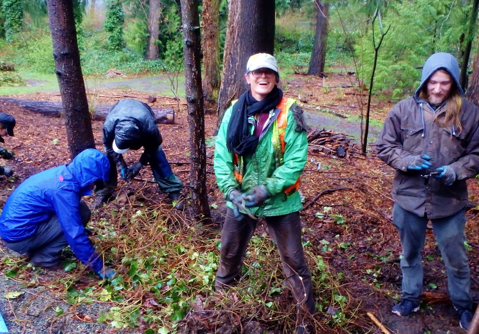
On one of those rainy, mucky days, I joined some friends from Blue Heron Zen Community to team up with the Friends of Jackson Park Trail and Thornton Creek Alliance and pull invasive weeds along the Jackson Park Trail in north Seattle.
It was wet and muddy, sometimes it felt like an exercise in futility, but it felt good to be out there with other civic-minded people. We smiled and laughed a lot, then ate pizza together huddled under a tarp.
I highly recommend taking a few days each year to volunteer.
April
Indeed we had April showers in 2017 as our wet spell continued into spring. Rain be damned, I went to the University of Washington Quad to catch the cherry blossoms in bloom. This has become a tourist pilgrimage now, so the rainy day kept the crowds down.
Another destination that's especially brilliant in the spring around here is the Bloedel Garden on Bainbridge Island. On the way there in April, we stopped and visited the grave of Chief Seattle (Sealth, Suiat'l) in Suquamish on the Kitsap Peninsula.
I was moved thinking about what this region was like in his lifetime and how it has changed. I felt connected in a small, not-so-nice way, as I've been told that his daughter worked as a maid for my great-grandparents on Alki in West Seattle.
May
Our heavy rains abated, and May brought beautiful weather for some great hiking in western Washington. Besides another hike with the Alpine Trails Book Club to Boulder Creek, rich with waterfalls, I rambled along the Mid-Fork Snoqualmie River Trail outside North Bend east of Seattle.
Years ago this was harder to reach with miles of dirt road; today much more is paved. But the reward is still great. You can walk miles through a lovely forest with occasional views like below.
June
To help a longtime friend celebrate a milestone birthday, a group of us journeyed south to the central Oregon coast for a weekend. When I moved from Portland to Seattle for college, I used to miss what I called "real beaches," the dramatic Pacific coast beaches along the Oregon coast.
I snuck out for a hike at Cape Perpetua Scenic Area just south of Yachats, where the views southward are stunning. Well worth a visit, and if you go, plan to spent a whole day exploring if you like to hike.
July
With snow retreating from the higher elevations, I joined a friend for an exhilarating hike up to Third Burroughs on Mt. Rainier. If you do this hike, you must go on a clear day for the brilliant views.
At about 10 miles round-trip from the Sunrise parking lot, this hike is a great workout. As always, go early!
Several friends joined me for a fantastic hike up Beckler Peak on Fourth of July, just below Stevens Pass. En route below the summit, we passed this little guy.
August
I used to say that August was my favorite month, although these days I trend toward October. But ah August, the rich, well-seasoned later summer, is a great time here in the Northwest.
We were plagued by intensely smokey days from forest fires raging throughout the region, but on early morning of the total solar eclipse day, skies cleared for perfect viewing in western Oregon. What an absolutely awesomely amazing thing to witness!
We were camped at a farm near Silverton, Oregon, and also got in a lovely hike in Silver Falls State Park. Go if you can...early.
September
Some say September is the shining star month here in the Pacific Northwest. Often we have Indian summer conditions, the pesky summer bugs have mostly gone away for the year, and it's a fantastic time to hike, kayak, or whatever outdoors pursuit you like.
A highlight for me was a gorgeous, invigorating hike up Mt. Townsend on the northeastern edge of the Olympic Mountains.
On a sad note, the Eagle Creek Fire engulfed large swaths of our treasured Columbia River Gorge National Scenic Area forests.
October
A nice day in October is a treasure. I now claim October as my favorite month for the fall colors, the touch of winter sometimes creeping into the air (skiing!), the end of the fall harvest (Washington apples!), and much more.
In 2017 I got over to the Leavenworth area and beyond to Stehekin on the upper end of Lake Chelan. I love north-central Washington for its drier climate but beautiful rugged mountains. Great hiking too.
November
Usually our first snow in the mountains comes in November, and 2017 was on target as usual.
On a chilly clear November day, the Snow Lakes Trail above Icicle Creek outside Leavenworth was pretty much all ours. In the summer this trail is full of hikers and climbers, some en route to the Enchantments or just the Snow Lakes above. But again, off season is the time to go for more solitude. (If that's what you like.)
December
And here we are as I write this. It has been a hectic, whirlwind of a month with the holidays.
I've not gotten out much except for a few good walks in Seattle's Discovery Park. Not a bad place to walk, really. In fact, I'll get more enthusiastic and call it an urban treasure featuring a lowland forest, prairie bluffs, beaches, and stunning views.
It's time to think about skiing, which I hope to be doing over New Year's. But also, for me, the turning of the year is a time to take stock of the year past and the year ahead.
What will 2018 bring? Stay tuned for more Pacific Northwest (and beyond) adventures. Wishing you and yours a happy, fulfilling, fun, and peaceful new year.
Happy trails and thanks for visiting Pacific Northwest Seasons! In between blog posts, visit Pacific NW Seasons on FaceBook, Twitter, and Instagram for more Northwest photos and outdoors news.






 Posts
Posts