Showing posts with label Bicycle rides. Show all posts

Friday, October 10, 2014

Bicycling Vancouver, B.C.: Easy Does It

When in Vancouver, B.C., be sure and have a bicycle ready to ride. What a great way to see this gorgeous city and get some good exercise!

On a recent weekend road trip from Seattle to Vancouver, we decided to bring bicycles.  Wise choice. Vancouver has it all over Seattle as a bicycle friendly city, with well-established and safe bike lanes.


 From the English Bay Bed & Breakfast where we stayed and had the indulgent breakfast shown below (splurge, but nice), we bicycled over 20 miles around the city all day on Saturday, with multiple stops to eat and take pictures.


While we couldn't find a bicycle trail map, the trails were easy to find and well-marked.  From our B&B, we hopped just two blocks down to the Seawall that extends 22 kilometers along most of the waterfront in the West End.


Our first stop was Granville Island after crossing False Creek on the Burrard Street Bridge. Sure it's tourist Grand Central, like Pike Place Market in Seattle, but it's fun to see the gorgeous food stalls and enjoy the waterfront.


Granville Market

Then we headed west up Fourth Avenue (and then up side streets) all the way out the Westside/Point Grey Peninsula to UBC (University of British Columbia) to visit the Museum of Anthropology. The going was very pleasant, with some mild uphills through leafy, prosperous residential neighborhoods, and a great viewpoint park.

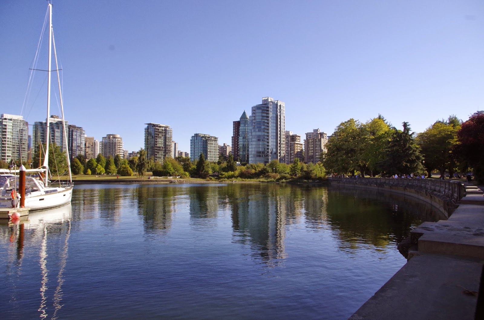
Looking back east towards the West End from  Point Grey area
Looking north toward North Vancouver and Coast Range beyond

We calculated about 4 or 5 miles out to the UBC campus, with several hundred feet in gradual elevation gain. After a great visit to the museum, we meandered back to Broadway for a tasty lunch along this busy street.

Then we cut back to the West End across the Burrard Street Bridge again, with a safe and well-traveled bicycle/pedestrian lane on each side of the bridge. Of course we had to stop for the views.


Because we'd only been out for 5 hours :) and it was a gorgeous day, we decided to continue on around Stanley Park on the Seawall. Not too far along we discovered that bicycles can only travel counterclockwise on the trail. With the  help of a friendly well-situated local, we managed to cut across the middle of the park and get to the other side to continue bicycling.


In the woods, Stanley Park


I can't get over the nonstop glorious scenery along this trail. As we rounded Brockton Point (and a wild party in progress) over to the Burrard Inlet side, the trail traffic thinned out a bit.  We had to stop several times to take pictures.

Looking across Burrard Inlet to North Vancouver
Occasionally along the trail at higher-traffic spots, bicyclists are required to dismount and walk, and sometimes the trail is not very wide. But it's one-way, so no worries.

Lion's Gate Bridge
The high and narrow Lion's Gate Bridge span always scares me a little bit to drive across (like the Tacoma Narrows Bridge too). Call it a healthy fear of heights. But no problem bicycling beneath it along the Seawall.

After winding around to the western, English Bay side of the seawall, we slowed down and savoured the end of this scenic day of good exercise.


The next day we hopped on our bikes again and cycled along the Seawall down to Yaletown and then back through the heart of the West End back to English Bay. Very pleasant, very easy, very safe.

For more photos of Pacific Northwest adventures between blog posts, Like our page on FaceBook. Thanks for visiting Pacific Northwest Seasons and happy trails!

When You Go 
Here is a link to an official City of Vancouver cycling map; however, we bypassed some trails on the Westside to travel along quiet residential streets. If you don't bring your own bicycle, it's easy to rent one. We stopped by English Bay Bike Rentals to ask about maps, and they were very helpful.


Wednesday, December 4, 2013

Perfectly Portland: In and Around Downtown by Bicycle

Of course the day starts with a stop at an organic juice bar. It's Portland.

On a recent sunny but cold Saturday, my well-situated friend Matt and I enjoy an easy breezy bicycle ride through P-Town.  Bundled up against the early winter chill and the East Wind, we coast from Goose Hollow down to the Willamette River.

But first there's that stop at Kure Juice Bar on Taylor a couple blocks up from the river. They whip up a cleansing concoction of veggies and fruit to get me revved for the ride.

After a tumble onto the street when my shoelaces get wrapped up in my pedal (good thing the street was empty), I pick myself up and we cycle onto the Waterfront Park - Eastbank Esplanade Loop Trail along the river.

Today we're headed clockwise and cross the river on the historic Steel Bridge over to the Eastbank Esplanade. This lovely trail is scenic and spacious, perfect for whatever means of nonmotorized transportation you wish.

Steel Bridge across the Willamette River

After cruising about a mile or so along the eastbank, we cross over the Hawthorne Bridge (I think!) and cut south along the river for our next stop. Portland's bridges have excellent, wide bicycle lanes.

Our next stop is the Little River Cafe along the RiverPlace Esplanade for a proper breakfast.  My breakfast wrap stuffed with freshly sauteed veggies, eggs, and a little cheese is excellent and large enough to split.

Then we continue south down to catch the Portland Aerial Tram up to the gorgeous OHSU (Oregon Health & Science University) facility on Marquam Hill above the South Waterfront District. When I was a kid this was just industrial land along the river, but Portland has grown up quite nicely, thank you.

We roll our bicycles onto the spacious tram that departs every 5 minutes or so and enjoy the short ride uphill. The view along the way is just as awesome as from the top.


 Mt. Hood is out in all her freshly white-clad glory today, looming large but graceful on the eastern horizon. Love that mountain.

Marquam Bridge
Lots of tourists and locals come up here for the view, and some lucky people like my friend Karen ride the tram as part of their daily work commute to OHSU. We chat up several visitors, including some students from Malaysia and a medical resident out from Kentucky.  A spectacular view on a sunny day makes everybody friendly.

Portland Aerial Tram
Riding downhill from OHSU on the winding, tree-lined road is more exciting than the leisurely tram ride up.  I cringe when Matt shoots down hill upright on his bike while he's adjusting his parka.  I'm too chicken and cruise down with a tight grip on my handlebars as I negotiate the blind curves.

Our last stop is back downtown at the Portland Farmer's Market at the South Park Blocks at Portland State University.  I stock up on the last of the season's chanterelle mushrooms and sneak a few cookies from one of the vendors closing up for the day.

After about 4 hours we meander back to Matt's place in Goose Hollow. Compared to Seattle where I live now, bicycling Portland is a dream. Lots of great trails, not too steep (we cheated with the tram), and very bicycle friendly.

Where are your favorite routes to bicycle around Portland?

When You Go 
The Portland Aerial Tram only cost about $4 to ride, payable by credit card. The Portland Farmer's Market at Portland State is open until December 21 for the year, then reopens in March.


Saturday, June 2, 2012

Bicycling the Centennial Trail: Rails to Leisurely Trail

With miles of flat, paved trail alongside bucolic farms, wetlands, and lowland woods, the Centennial Trail in Snohomish County, Washington, is a perfect route to ease in your bicycling legs.  We headed up to Snohomish last weekend for a leisurely ride and to avoid the weekend crowds on the more popular Burke-Gilman Trail from Seattle to Redmond.

While the Centennial Trail currently extends 23 miles north from the city of Snohomish just past Arlington, and is planned to reach all the way to Skagit County, we cycled about 10 miles up and then turned around and came back. Twenty miles was just fine for my first day on a bicycle this year.

For the first few miles up to the historic Machias train station (a replica) and trailhead park on this former Seattle, Lake Shore, and Eastern Railroad  route, we passed homes and farmland and skirted alongside the Pilchuck River. Even though this was Memorial Day weekend, traffic on the trail was pretty sparse, unlike the Burke-Gilman "bicycle freeway."


And so it continues northward through quasi-rural and then increasingly rural country.  This being the Puget Sound region, I was expecting at least an espresso stand on the trail.  The closest was a little stand about 50 yards or so off the trail across the street from the Lake Connor corner gas station/market, where we stocked up on cold water. This little store is a treasure trove of old commercial signs.


Beyond that, there is nowhere to grab a snack or drinks along or near the trail, at least for the first 10 or so miles.  In Lake Stevens, you can hop off the trail and pedal 3 blocks into town. Otherwise, pack your own grub and, of course, water.

North of Lake Stevens for several miles, the trail passes through completely rural landscape.  We sped past horseback riders and finally pulled off where we saw a sign for a park.


As far as parks go, it was pretty unimpressive.  Methinks it is just a place for people to park their horse trailers and saddle up. We turned around and headed back south.

At occasional spots on the trail, snow-covered White Horse Mountain, Mount Pilchuck, and other lesser Cascade peaks pop out on the eastern horizon.


After returning to the trail terminus in Snohomish, we went to historic downtown Snohomish for dinner at Fred's Rivertown Alehouse and then a stroll along the Snohomish River Trail. Fred's is a lively spot that offers decent pub fare and lots of beer and spirits.


All in all a relaxing way to start the summer bicycling season.

Have you bicycled the Centennial Trail?  Have you gone all the way up to Arlington?  We'd love to hear about your experience on the trail in a comment below, especially if you've bicycled the whole trail.

When You Go
Here are links to a map of the trail that shows several access points and directions to the trailheads. I'd like to go back and start farther north to see the northern end of the trail.


Tuesday, August 9, 2011

Wenatchee Weekend: Bicycling the Joe Miller Loop

Sometimes you just have to follow the sun. With our decidedly unsummer-like weather this summer in western Washington, I decide in about, oh, 0.05 second to accept a former college roomie's invite to Wenatchee for the weekend. That's east of the Cascade Mountains, the dividing line between cloudy and sunny this summer in the Pacific Northwest.

In case you don’t already know, the greater Wenatchee area and valley stretching up to Leavenworth is an outdoors lover’s Mecca. (Beautiful Lake Chelan is also not too far away.) Think great downhill, backcountry, and cross-country skiing in the winter. Warmer weather brings ideal conditions for rock climbing, hiking, river rafting, kayaking, waterskiing, bicycling, and more in a warmer, drier climate than the “Coast.”

No wonder my friends who live there are all fit, healthy, and happy.

As with many of my friends, Linda and I bonded over a shared love of skiing and outdoor adventures. So I’m not surprised when she and her husband propose an afternoon bicycle ride.

Since temps are expected to be over 90áµ’F (a shock to my mossback constitution!), Don suggests we ride a route known locally as the Joe Miller loop, much of which is over 1,000 above the valley floor. When riding counter-clockwise from Wenatchee, this roughly 25-mile loop rises steadily, then steeply up to a plateau in Stemilt Basin.

Many riders go clockwise to avoid the steep hill, but we cheat and drive up to where the route levels out atop the plateau, park the truck, and then start riding. Up here the views up to forested Mission Ridge and down toward the arid Wenatchee Valley are expansive and awesome.

This is orchard country, prime land for growing cherries, apples, pears, peaches, and apricots. So we start out under bright, intense sun on a gentle grade past trees heavy with fat red cherries ready for harvest. To our right the basin drops toward a farm.


“There’s an unofficial longboard race going on, so watch out and keep off the road for a bit,” says a woman standing on the side of the road just as we’re starting up the first hill. We pull over into the shade of ponderosa pines beside the road to watch (ah, relief from the sun, which is zapping me already). Pretty soon leather and helmet-clad guys go whizzing past, bent forward like Apolo Anton Ohno in a speed ice skating race. Those dudes are going scary fast!


After we cycle a bit higher and hit a few sharp switchbacks, a big pickup drives past piled full of the racers heading back up to the starting line. I'm glad to have an excuse for another break (it's the heat!) when we ascend to their start, where racers are lined up for the next run.


"Racers ready!" cries the starter. And they're off in a blur of leather and wheels, tailed by a chaser. A couple more tag-alongs try to join in, but the starter yells them off. "Dudes! Stop! No more!"

For the next half hour we meander along a winding country road past orchards, pine forests, and a few nice views of irrigation lakes and the dusty brown Columbia Basin steppes beyond. Sure there are more than a few potholes, but that’s okay because it’s so nice to be riding along a quiet, scenic road.


Then we emerge back into more orchards and agricultural land. Bucolic farms spread out in patchworks around the valley below, with snow-covered Glacier Peak off in the distance to the northwest.


“Here’s the biggest downhill stretch," says Don. We coast down the sinuous road, hands on the brakes around tight curves, until we come to an intersection with a cute little white clapboard church on a corner. Then we turn right on Joe Miller Road.


From here the grades lessen, but it’s still nice and easy cruising through Malaga past farms and small ranches with horses grazing beneath stunning Columbia River basalt ridges.


Within a few miles we end up down at the Malaga-Alcoa Highway, which flattens out and travels along the Columbia River. Until we got to the highway, I think only two trucks passed us in over an hour of riding! Our last few miles along the highway back to Wenatchee are a slog under the hot sun.


Back in town, I have to rest in the shade to cool down, gulping cold water while Don and Linda drive up to get the truck where we started. This Westside gal is not used to the heat! But a little too much heat and lots of sweat is worth it for this great ride. I earned the calories for my wonderful dinner this evening at Shakti's.

When You Go
If you can, I recommend riding this loop in the morning during the summer. In the fall and spring, I’m sure it’s a spectacular ride. By driving up to the top of the plateau, we cut our ride to a tad over 19 miles. Here’s a map of a slightly longer version of the route, starting in East Wenatchee across the Columbia River.

Here's the route as we did it: Head south out of Wenatchee up the Squilchuck Road towards Mission Ridge. About 4 to 5 miles on, turn left on Wenatchee Heights Road and go up the steep hill. We parked and started at the top of the plateau across from funky sign pictured to the right. This road turns into Stemilt Loop Road, which we followed across Stemilt Basin for about 10 miles to the little white Baptist church. Take a right down to Joe Miller Road, winding down several miles to West Malaga Road, which we followed to Malaga-Alcoa Highway (mostly flat along the river), and then back to Wenatchee along the highway.