Tuesday, October 17, 2017

Weekend in Stehekin: Celebrating Autumn and Community

Want to really get away from it all? No wifi/cell reception, traffic, and streetlights, and quiet-except-the-sounds-of-nature away from it all?

It's getting harder since the Pacific Northwest has become a magnet for the thousands moving here the last several years. So a recent weekend getaway to Stehekin, way up in the mountains at the northern end of Washington's Lake Chelan, was a balm to my city-addled soul. 

No roads lead to Stehekin. You can only get there by boat, small plane, or walking in over mountain passes (which I did many years ago). Any way you go, it's a journey.

The Voyage North
Friday morning we caught the once-a-day ferry at Fields Point Landing north of  Chelan for the 3-hour cruise up lake on the Lady of the Lake. We snagged two seats in the fore bow, but spent most of our time out on the back deck in the breezy sunshine.

Lady of the Lake


Along the way up the lake, it was disheartening to see the formerly forested mountains hugging the lakeshore now mostly bare with stands of dead snags, remnants of the many forest fires that have raged here the last two decades. After about 3 hours and a few stops along the way, we arrived at the collection of wood-framed low-rise buildings that are more or less "downtown" Stehekin.


The Arrival
Our lodging over the weekend was at the North Cascades Lodge (pictured above) adjacent to the boat landing. We came for a "Fireside Circle" weekend with Washington's National Park Fund (WNPF), a great nonprofit that raises funds to supplement projects in our under-budgeted national parks here in Washington. 

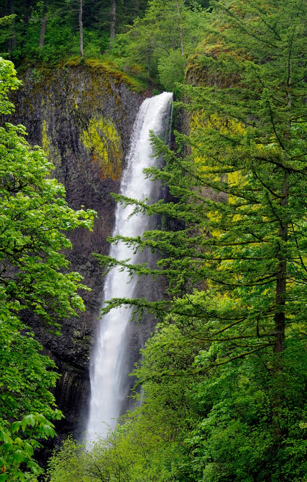
WNPF had a full weekend of activities planned, so after settling into our rooms, most of our group of about a dozen hopped on a park shuttle to Rainbow Falls for a short walk, followed by a stop at the famed Stehekin Pastry Company. For a cookie monster like me, it's a dangerous place.

Lower Rainbow Falls
The Main Events
Our weekend was organized around the annual Buckner Orchard Harvest Fest, which started with music Friday night at the one-room Stehekin School. While a couple of the amateur musicians stumbled on lyrics or chords, the easygoing crowd sang along in encouragement. A highlight was the school kids singing and a sweet father-daughter duo.

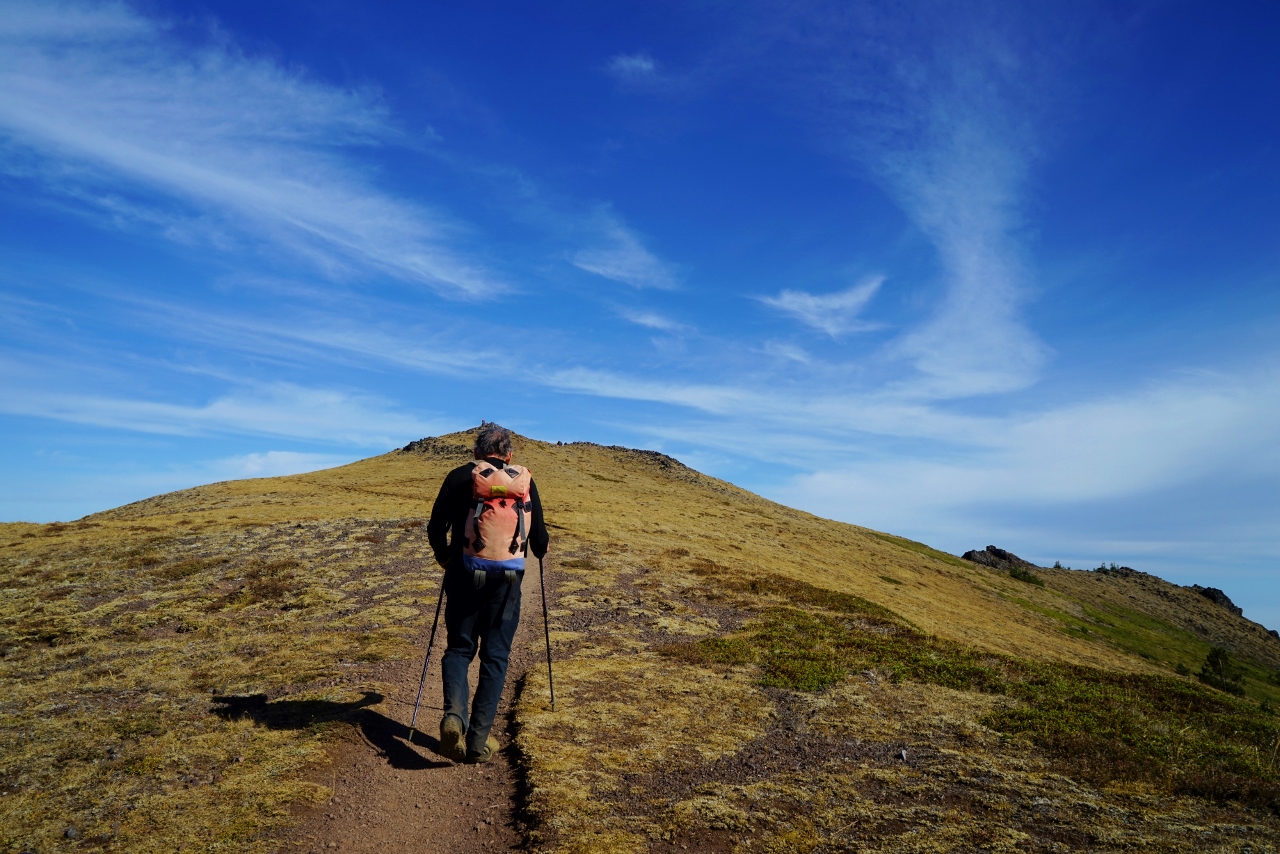
Saturday morning before the cider squeeze, some of us hoofed about 1,000 feet up the Purple Pass Trail behind the lodge before heading back down to catch the shuttle to the orchard. (Would like to go all the way up to the pass next time for even better views.)


A few miles beyond the head of Lake Chelan lies the Buckner Homestead, a designated Historic District inside the boundaries of the North Cascades National Park complex.  Our destination was the the organic orchard, which is so isolated that no pesticides are needed. 

naturally organic
Everyone was welcome to pick beautiful apples to take home, but the real focus was the cider squeeze. Local musicians played as we feasted on the community potluck. Of course everything was homemade because there are no grocery stores anywhere near Stehekin. We filled our plates with delicious chili, cornbread, salads, flaky fruit pies, and cookies.


In this beautiful setting surrounded by mountains and exceptionally friendly locals, I was sold on the benefits of living in such a remote community many miles away from strip malls and box stores. It's a throwback to a simpler, rural American small town way of life that is sadly disappearing.

The Last Morning
When I awoke before sunrise after another night of deep quiet and a restful sleep, I grabbed my cameras and ran out to shoot the sunrise from the lakeshore. Although it was chilly, we were treated to a lovely show of changing light on the snow-dusted mountains above.


After breakfast at the lodge, most of our group caught the national park shuttle up the dirt road beyond Stehekin as far as it goes (about 12 miles). First we stopped at a Stehekin River crossing to see an abundance of crimson red kokanee salmon heading upstream to spawn. 

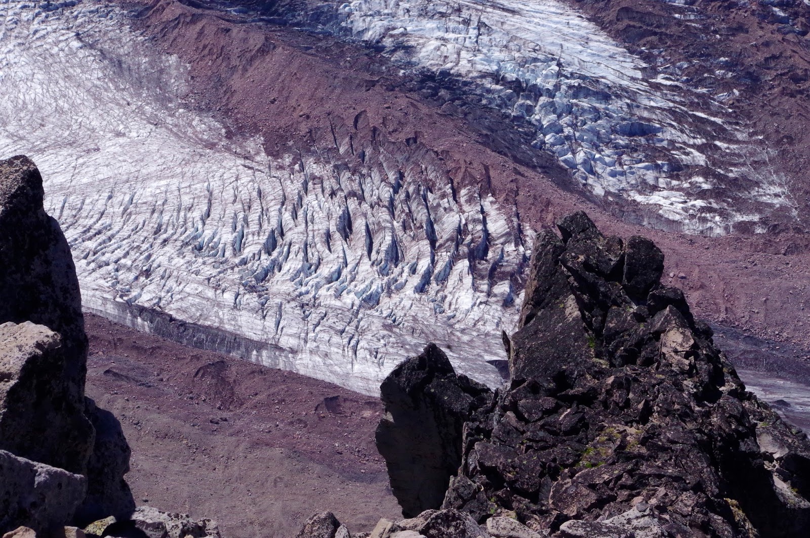
At road's end, with about 15 minutes to hop out, I shot a few photos a short way up a trail. 'Twas indeed another beautiful day in the North Cascades, freshly frosted with new snow that fell over the weekend.


Before departure at 2 pm when the Lady of the Lake headed back south, several of us took full advantage of our last hour in paradise with a walk along the Lakeshore Trail as far as we could go. Then it was time to leave.

Too soon.


The pace of life in Stehekin

Cramming a beautiful weekend of fun, great people, and more photos into one blog post is tight, so I'll leave it at that. You'll just have to see for yourself sometime.

We'd love to hear your Stehekin/Chelan/North Cascades experiences or answer your questions in a comment below. 

Happy trails and thanks for visiting Pacific Northwest Seasons! In between blog posts, visit Pacific NW Seasons on FaceBook, Twitter, and Instagram for more Northwest photos and outdoors news.  
 
When You Go

While you can visit Stehekin year-round, things do slow down in the winter. The Stehekin Pastry Company just closed last weekend for the season; look for it to reopen next spring. While we stayed at the convenient North Cascades Lodge at Stehekin, there are other options, like the cool Stehekin Valley Ranch. Here's the link for ways get to Stehekin. Hiking into and around Stehekin is my favored activity, but there are lots of other things to do.
And last but not least, think about getting involved or donating to Washington's National Park Fund. These days our parks especially need extra support.


Sunday, September 24, 2017

Hiking the Olympic Peninsula: Panoramic Mt. Townsend

When a friend from the East Coast asked me to take her on a Pacific Northwest adventure a few years ago, I wanted to plan a quintessential Northwest experience. We only had a couple days, so it couldn't be too far from Seattle.

Since I consider a ferry ride across the Salish Sea a must for visitors (sometimes you see whales!), I decided an overnight in historic Port Townsend then a hike up Mt. Townsend would be perfect. On a clear day, this mountaintop ridge at the northeastern corner of the Olympic Mountains offers sweeping, magnificent 360 views. 

From the summit, you can see downtown Seattle and the Cascades Mountains across Puget Sound to the east, Mt. Baker floating above foothills and islands to the northeast, Vancouver Island in Canada across the Strait of Juan de Fuca to the north, and the craggy Olympics peaks to the west-southwest-south. 

Well....on a cloudy mid-July day, the higher we hiked up the mountain, the thicker the mist and fog. By the time we got to the summit, visibility was only about 20 feet. 


But still, it was lovely in its own damp, enveloping way. We Northwesterners don't cherry pick the nice days to get outdoors.

Fast forward to a recent beautiful September daythe best kind of hiking day around here. It's not too hot, not too cold. Pesky bugs are done for the year. Our days on the trail before the snow flies at higher elevations are numbered, so a fall hike is especially sweet.

And even sweeter if it starts with a ferry ride during a colorful sunrise.

Edmonds to Kingston

From the ferry terminal at Kingston, the drive to the trailhead off Highway 101 near Quilcene took about 90 minutes, some of it on gravel Forest Service Roads. When we arrived at the upper trailhead around 8:30 a.m., a group of volunteers from the Washington Trails Association tried to recruit us to help with trail work. Another time.

Rich green forest thick with rhododendrons encompasses the first mile or two of the hike, although we noticed the rhodies looking droopy, no doubt due our driest summer ever. (Come in May for a spectacular rhododendron blossom display.)


Within a mile or so, the trail starts moving in and out of the woods, revealing views up mountain and down valley. After about 2.5 miles, we cleared most of the forest, and the rest of the hike is through meadows, subalpine trees, and occasional krummholz to the top.

I remember thinking the switchbacks were brutal when I hiked here on a some backpack trips to Silver Lakes, but none of it is very steep. (I think the trail has been regraded a bit since my earlier trips.)


As we crested the up-and-down ridge that runs along the mountain top, we're out in the open, with unobstructed views.

Final push to the summit.
We found some rocks to sit on and eat lunch at the summit, and Betsy and I grabbed extra layers from our packs in the cool breeze.  Then we rambled to the northern end of the ridge for the views north of the Strait of Juan de Fuca and the San Juan Islands/British Columbia beyond.

End of the line. Looking north, Salish Sea.
 
View northwest. Strait of Juan de Fuca to the right.


On our way back south along the ridge, we saw a low layer of mist rolling in and wondered if it was fog or smoke from our many forest fires. As it got thicker and brownish, we could tell it was obviously smoke.

Looking southeast, smoke to the left.
This is earthquake country. The Olympic Mountains are the result of a large uplifted and folded section of oceanic crust that has smashed into the continent and been thrust upward over the last 40 million years, at the margin of the Cascadia subduction zone

Some seismologists posit that the subduction zone is locked on the eastern side of the Olympics - that is, directly beneath Mt. Townsend. When the stress builds up too much, the plates will slip and produce a megaquake (9.0 or greater).

I'm glad it didn't during our hike. :)


With the smoke and morning clouds, we weren't able to see downtown Seattle nor much of the Cascade Mountains. Mt. Baker was barely visible above the smog. But no matter, it was still an exhilarating hike and workout.

And on the ferry ride back to Edmonds, I was lucky enough to notice something dark just above the waterline not far north from the ferry. Definitely not a boat. As it submerged I saw the unmistakable fluke tail of a humpback whale thrust up out of the water right before it disappeared. I've spent most of my life here and never before have spotted a humpback in my home waters.

Excellent cap to  a splendid day.

Happy trails and thanks for visiting Pacific Northwest Seasons! In between blog posts, visit Pacific NW Seasons on FaceBook, Twitter, and Instagram for more Northwest photos and outdoors news.

When You Go
Elevation gain on this hike is just a tad over/under 3,000 feet (depends on whether you trust your GPS or the WTA trail guide), and mileage is about 8 miles roundtrip. There are several trailheads for hiking up Mt. Townsend, but we chose the upper trailhead, accessed from Quilcene to the east. A lower trailhead starts a little over a mile below and goes through some impressive old growth forest, which I did some years ago.There is also access from the western/Sequim side, but it's a steeper trail.

To access the upper trailhead, take US 101 south from the Quilcene Ranger Station 0.9 mile, the take the slight right onto Penny Creek Road. In 1.5 miles, take the left fork onto Forest Road 27 and follow it 13.5 miles before turning left onto FR27-190. The trailhead is at the end of this spur road, and there's a vault toilet there. Since this is in the Buckhorn Wilderness, east of Olympic National Park, no passes are required to park.

Wednesday, September 6, 2017

2017 Columbia River Gorge Fire: Grief and Hope


As I write this, the Eagle Creek Fire is still burning and growing in the Columbia River Gorge, threatening towns in eastern Multnomah County, Oregon.

In just one night, it engulfed some of the most unique and verdant landscapes on the planet in a maelstrom of exploding trees and racing flames, fanned by the Gorge's famous East Wind. A friend watched a whole mountainside go up in flames in about one minute.

It's too early and I've yet to see it, so I still can't quite conceive of what has happened. Has this sacred, nourishing, touchstone place for me, where I return as often as possible, been irrevocably changed, denuded, and altered forever (at least in my lifetime)?

This I can't yet comprehend.


Gorge lushness
 As a post on the Friends of the Columbia River Gorge FaceBook page said,   "We're hoping for the best, but fearing for the worst."

The Vista House on Crown Point. Still standing.


I'm having a hard time putting into words how important the Gorge has been to me throughout my life. It is, as they say, in my bones.

When I was three my family moved to the Troutdale area, where our home was just a few miles from the basalt cliffs across the Sandy River that mark the western entrance to the Gorge. I grew up there learning to love nature, waterfalls, and walking in the woods.

On warm summer nights, my mom would pack a picnic dinner and we'd head up to enjoy the particular refreshing cool in the woods near one of the waterfalls. We often had Oneonta Gorge to ourselvesonce my dad featured a shot of my sister and I there on the front page of his newspaper, calling us "woodland sprites" in the caption. (We got teased for that.)

Below Larch Mountain

As a teenager I started hiking/backpacking in earnest and explored the Gorge's trails more extensively.  Maybe it's because I was 17 and all my senses were heightened, but one great backpack trip stands out: 

Towards the end our hike from Mt. Hood down to the Gorge, I vividly remember the soft, forgiving earth underfoot and the richness of the forest as we descended switchbacks nearing Eagle Creek, singing silly trail songs. (Because back then there were no other hikers around to annoy.) To wash away some of the week's grime, we jumped into a pond in the upper creek. Decades later I can still almost feel the bracing, exhilarating chill from jumping into the icy cold water that left my skin tingling afterwards. When we arrived at the Eagle Creek trailhead, our parents had spread out a picnic for us, which we devoured after a week of Top ramen, dried salami, and homemade gorp. Fantastic memories!


Throughout my life the Gorge has been a place of refuge, a soothing balm for my soul. I’m a firm believer that Heaven is here on Earth and that it’s unique for everyone. My version encompasses the verdant western Gorge and its many trails.

At one of my happy places
 After hiking there I feel energized and especially alive. There’s something magical and life-affirming about the abundant and thriving plant life, coursing streams, and cascading falls.

I heard there are pockets of trees spared, and yes, there will be regrowth. But it will take time. A long time. And who knows how climate change will affect the ability of such a unique botanical treasure to return to its former fecund glory.

Lower Multnomah Fall. The cedar to the right appears to have survived the fire
So allow me, us, to grieve while we also carry hope that enough was spared from the flames to allow a quick natural regeneration and healing of the unique collection of ecosystems in the Gorge.


Remnant snags from an early 1990s fire atop Angel's Rest

Eagle Creek, Punchbowl Falls
Bicyclist on the historic Columbia River Highway just below Crown Point
Thanks for "listening." I'd love to hear what the Gorge has meant to you and your experiences there in a comment below.

Happy trails and thanks for visiting Pacific Northwest Seasons! In between blog posts, visit Pacific NW Seasons on FaceBook, Twitter, and Instagram for more Northwest photos and outdoors news.


.

Friday, August 25, 2017

Eclipse 2017: In Celebration of a Family Farm, Friends, and Pure Awe

The "diamond ring" emerging from totality. Photo by Allen Denver.

In today's hyper-speed news cycles, the 2017 total eclipse that sliced across the USA on August 21 is old news. But in the days since, I've been replaying that amazing 1 minute and 48 seconds in my mind, lingering over the too-brief spectacle.

It was the most thrilling, mind-bending, magnificent natural event I've ever experienced.

The bonus? It capped a wonderful weekend on a family farm in the Willamette Valley filled with happy, interesting people, great food, and kick-back fun.  Life doesn't get much better.

Over 40 people and 7 dogs converged on the farm situated conveniently in the path of totality. We ranged in age from 6 to almost 80. Many of us pitched tents in the orchard, some slept in RVs and campers, while others lodged in the barn.


As people arrived over several days from Seattle, Portland, and even Santa Cruz, California, it was fun to meet old friends and make new ones. As Tonia said, it was like "a family reunion with the people you like even though some of us had never met."

Some went hiking and exploring in this beautiful, pastoral patch of the valley near Silverton, and some stayed close to relax, cook, or read. Several kids picked fat, sun-ripened blackberries for pie, which hostess extraordinaire Mary Lou helped them make.


The taste of late summer in the Pacific Northwest.

Although there was a possibility of clouds, I awoke before sunrise on Monday morning and peeked out of my tent to see sweet clear skies. As fast as possible, I threw on a fleece sweater and jeans, grabbed my cameras, and ran out in the morning quiet to shoot the sunrise, my favorite time of day.

 
Eclipse day sunrise - minus 4 hours.

After another hearty breakfast of farm fresh bacon, eggs, fruit, pancakes, and more, the anticipation edged up several notches.  We spread out in a couple open fields and patches with good views to the east, set up chairs and cameras, got out our eclipse glasses, and watched as the moon slowly crept across the sun in tiny but increasingly large increments.

Sheet spread out to catch the post-eclipse wave shadows.
About half an hour in, the light started to visibly dim, the temperature dropped, and a slight breeze picked up. I reached for my jacket and put it on.


As the moon encroached more over the sun, the light was unlike anything I've seen, as if someone turned down the dimmer switch in the sky.


Shortly before totality the roosters started crowing, and I heard what sounded like an owl hooting from the patch of woods behind the field. A short hush fell while the last sliver of light faded from view, as if everyone held an intake of breath for an extra second.

When I could no longer see any light at all through the eclipse glasses, I tore them off.


That first stunning glimpse of a big black circle in the black sky, surrounded by the white glow of the sun's corona shimmering outward in delicate filaments of light, will forever be seared in my mind. 

(For you art history types, it reminded me a bit of the dramatic crown of thorns in Grunewald's famous Eisenheim alterpiece, only more exquisitely gossamer.)

All the photos I've seen don't quite capture it. But they're close.

Totality. Photo by Allen Denver.
People whooped, I heard what sounded like a bomb or fireworks go off in the distance, and I found myself bouncing around, saying to no one in particular, "THIS IS SO AWESOME!!"

I'd heard people say to look around, so I did. In this instant predawn/dusk, there was a tinge of red on the horizon in every direction. 

Then I grabbed my camera and snapped some shots, put the camera down, put on my regular sunglasses and gazed up at that wondrous sight above again. I remember thinking, if this was a few thousand years ago and I didn't know what caused this, it would be a fearsome sight indeed.

Far too soon totality was over. I wanted more.


Some of us drove away quickly to try and beat traffic (no such luck) and some people stayed another night at the farm. I waited until after dinner and headed north at 6 pm. After 8 long hours on the road without a break, I pulled up to my home in Seattle at 2 a.m.

Of course I want to see another total eclipse now. Next time I wouldn't try to take any photos and would instead focus more on the sun and surrounding sky during totality, without sunglasses. I'd heard conflicting things about the safety of viewing without any protective lenses during totality (consensus: it's safe). As a result, I missed seeing the stars in the background around the sun.

So how about you? Did you make it to the totality zone and see this spectacular phenomenon? If so, how did you react or feel? Would love to hear about your experience in a comment below.

And perhaps Chile in 2019?
Photo by Allen Denver.

Happy trails and thanks for visiting Pacific Northwest Seasons! In between blog posts, visit Pacific NW Seasons on FaceBook, Twitter, and Instagram for more Northwest photos and outdoors news.

Thanks to Allen Denver for letting me use some of his great eclipse photos. And extra special thanks to our generous and gracious hosts Mary Lou and Ben.


Wednesday, August 2, 2017

Hiking Mt. Rainier: Burroughs Mountain

"It's a five-wow day!" says my friend Mark as we're pulling into the Sunrise parking lot on Mt. Rainier. With blue skies overhead, a pleasant 70-ish degrees, and a day of hiking ahead, it doesn't get much better.

For maximum wow-ness, hiking up Burroughs Mountain on a bluebird day is ideal. This is my third time hiking up to Third Burroughs (beyond First and Second Burroughs to the trail's end), and each trip has been equally brilliant.

At elevation 6,400 feet on the northeast side of Rainier (which reaches 14,410 feet), Sunrise is higher and less visited than Paradise on the other side of the mountain. While several trails start and intersect here, the Burroughs Mountain trail goes the highest and closest to the jumble of crevasse-riddled glaciers on the mountain's flanks.

Even views from the parking lot are spectacular. A few weeks ago there, a visiting monk from Asia asked a friend to snap a shot of him sitting cross-legged on the pavement with Rainier in the background.


"If you don't have an ice axe and can't self arrest, the park is telling people not to hike up the Burroughs Mountain trail," says the friendly volunteer at the main trailhead. "There's snow on the trail and the potential for a dangerous slide down onto rocks."

I know they're being extra cautious. However, a couple minutes later we ask some hikers coming down the trail if they went up Burroughs.

"Yea, it's doable."

As we head up the dusty trail from Sunrise towards Frozen Lake and Burroughs beyond, we're definitely not alone. On a beautiful summer weekend, people from all over the USA and the world are out there with us Washingtonians.


Pretty much the whole trail beyond the initial stretch from Sunrise has sweeping, panoramic views. In about 1.5 miles we reach a junction just beyond Frozen Lake, and follow several other hikers on up First Burroughs.


When we arrive at the first patch of snow across the trail, it does indeed look a little dicey. I intentionally don't look down as I carefully tread on the slick, narrow track. I'm glad for my hiking poles, even though they mark me as a terminally unhip oldster.

The second and third snow crossings are shorter and easier, and soon we're atop the table-like summit of First Burroughs, with Second Burroughs not far ahead.


Atop First Burroughs

On a brilliant day like today, there's a festive atmosphere atop Second Burroughs. Everyone stops here for a break to revel in the splendid views, maybe snack and sip more water. At 6 miles roundtrip back to Sunrise, this used to be the turnaround point for most hikers, but today a steady stream is continuing on toward Third Burroughs.


Atop Second Burroughs, with Third Burroughs in the distance to the right.
After reaching elevation 7,400 feet on Second Burroughs, the trail drops about 500 feet down to a short plateau before the final, much steeper slog about 900 feet up to Third Burroughs at 7,820 feet. And today there's a significant snowfield over the trail. Onward.


Reminds me of trekking in the Himalayas
Slip-sliding up the steep snowfield is not fun. Some people were smart and brought slip-on traction for their boots. I'm lagging on the last few switchbacks before the summit, partly due to the intense sun reflecting off the high elevation snow (which gives me a bad sunburn on the back of my knees). Have I mentioned I'm a total heat wimp?

"Do you want to stop?" says Mark, being solicitous.

"I'm NOT coming this far and stopping," I shoot back, trudging up.

And then suddenly there we are, on a ridge that looks like you could hop and skip on straight up the mountain.

  
Which makes me feel like this:


Surprisingly, the crowds dissipate pretty quickly when we continue on a ways along the ridge. In about 30 minutes of lunching, gaping at the massive mountain/glaciers in front of us, and snapping photos, we only see one other guy up here.

On the back side of the rocky summit, the ridge drops precipitously, with a dramatic view down to the toe of Winthrop Glacier hundreds of feet below.  It has definitely retreated quite a ways since I was first here in the 1990s. (Yes, climate change is happening, and our glaciers are fast receding.)


Coming down the snowfield is much more fun than going up.  Mark zooms down in big leaping-sliding steps. So I follow, jamming my heels into the snow and sliding too.

Despite the 500 feet back up Second Burroughs, which is pretty mellow as far as climbs, the trip back is smooth sailing. We're not in a rush, so take a leisurely break on Second Burroughs again to soak it all in--this day, this hike, this massive volcano with impressive glaciers, dormant for now. Soon enough, we'll both be office-bound.

Snowfields across the trail on First Burroughs.
By the time we get back to the car, almost 7 hours have passed, about 2 hours longer than the same hike 2 years ago. We took lots of breaks, took lots of pictures, the snow slowed us down, and  I'm admittedly not in as good shape as a few years ago due to knee and foot issues. Mark's GPS indicated that we had hiked 9.9 miles.

"Do you want to walk to the end of the parking lot to hit 10 miles?" I joked. Nope. Both of us just want to liberate our feet from boots and get something cold to drink.

After Hike Eats
On the way back to Seattle, we stop at the classic Naches Tavern in Greenwater, the first town on the drive back down the mountain on Highway 410. Yea, the food is so-so (I got a grilled hot dog because they were out of veggie burgers and Mark got a cheeseburger), but the drinks are cold and there's great outdoor seating in the shade. It's worth a stop just to step inside this rustic old bar and grill, which was originally built in 1919. In the winter, it's hopping with skiers from Crystal Mountain.

Personally, I find hiking at and around Mt. Rainier exhilarating. Do you have a favorite Rainier hike?

Happy trails and thanks for visiting Pacific Northwest Seasons! In between blog posts, visit Pacific NW Seasons on FaceBook, Twitter, and Instagram for more Northwest photos and outdoors news.  

When You Go
Although Mt. Rainier is only 53 miles from Seattle as the crow (or raven) flies, by car it's closer to 90 miles. There are a few different routes, but we took I-5 south to Auburn and cut southeast through Enumclaw and up Highway 410 to the White River entrance to Mt. Rainier National Park. We left Seattle around 7 am and got to the entrance around 9, by which time we had to wait about 15 minutes in line to enter the park. It was a sunny summer Saturday, and they restrict entrance when the parking lots fill up, so go early. Entrance to the park costs $25 for a single car, but it lasts for 7 days.

Here's a link to a map of the park and vicinity on the park's website. When hiking on the mountain, be prepared for changes in weather, even if it's a warm sunny day when you start. Now go have a wonderful hike!