Saturday, February 27, 2016

Hiking Larrabee State Park: Fragrance Lake

I don't know that Fragrance Lake is particularly fragrant, but the hike there above Chuckanut Drive in northwest Washington is rich with scenic beauty: a serene forest-fringed lake, lush evergreen forest, and a sweeping panoramic viewpoint full of sea and sky.

This is my first time hiking in the Chuckanut Mountains, the only place where a branch of the Cascade Mountains stretches far enough west to meet the sea. It's a pleasant, mild late winter February day, perfect for a lowland hike. 


I'm here with the new Alpine Trails Book Club, organized by Ashley of Alpine Lily via her excellent Northwest-focused blog. While I'm the elder of the group by a long shot, when we're on the trail all equally enthralled by this beautiful forest, age doesn't matter.

We get a fairly early start on a Saturday, which is good because this is a very popular trail, just south of outdoorsy-minded Bellingham. I'd say this qualifies as what I call a Northwest "Greatest Hits" hike.

After parking at the main Larrabee State Park lot, we cross Chuckanut Drive, and start up the trail that plunges immediately into healthy forest, with some remnant old growth.


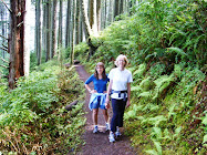
After hiking upward on gentle switchbacks for about 30-40 minutes, we take a quick water break. Ruby (one of the two dogs on our hike today; they didn't have to read the book :) flops over and lets us know she'd like to stay put for a while.


But she's a trooper and rallies as we continue through this beautiful forest on up to the lake.


In a flash of whimsy, I envision forest faeries inhabiting this stretch of woods, perhaps sleeping by day inside trees like the lovely old western red cedar pictured above. Maybe I'm influenced by the enchanting book we read (The Snow Child by Eowyn Ivey), which has hints of magic realism.

Soon enough we arrive at the lake and stop at a clearing below some of the exposed Chuckanut Formation sandstone rock walls along the shore, where we discuss the book and nibble snacks. (Thanks to Ashley for her delicious chocolate bark.)


While the weak February sun warms us a bit, the temperature drops to chilly as we hike around the lake into the shady side. It's still winter.

Circumnavigating the lake, we cross numerous wooden walkways and little bridges over muddy areas. The Washington Trails Association gives this trail a lot of attention due to its popularity, and we actually pass a WTA crew doing trail work on our way down.
Lucca on the trail around Fragrance Lake.
On the way down we take the short (0.2-mile) cut-off to a splendid viewpoint over the Salish Sea and the San Juan Islands beyond.  Although it was overcast when we started hiking, the sky has cleared up nicely for us.


From there we've only about a mile back down, and I can't resist stopping to hug at least one of the huge old cedars (my totem tree).


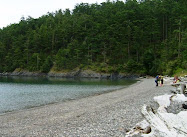
After using the restrooms at the parking lot post-hike, we drop down the short trail to the beach. Who doesn't love the combination of freshwater mountain lake and saltwater beach on the same outing?

There on the shoreline is the same Chuckanut Formation we saw up at the lake (the big rocks on the right). See more shots of this formation out on Sucia Island.

 
Ruby wants to stay put at the beach, too.

After Hike Eats
We're done hiking just after noon and decide to stop in the charming Skagit flats village of Edison for lunch. It's on our way back to Seattle, just a short detour west.   

This area (Bow-Edison) has become a hotbed for artisan food and artists, with a creamery making cheese nearby, a marvelous bakery, and several little cafes in the one-block town. We decide on Slough Food, a cozy little deli-cafe where we get excellent sandwiches, salads, and soup.


Overall it's a stellar day, with a lovely morning hike, great company, and tasty local food. If you make your way up (or down) there, be sure and savor the day. And let me know if you discern the fragrance.

Happy trails and thanks for visiting Pacific Northwest Seasons! In between blog posts, visit Pacific NW Seasons on FaceBook, Twitter, and Instagram for more Northwest photos and outdoors news.  

When You Go
The Fragrance Lake trailhead is directly across the road from the main Larrabee State Park entrance. We left Seattle about 7:10 and arrived there around 8:30 a.m., with not much traffic early on a weekend morning. You need a Discover Pass to park. Dogs are permitted on leash. According to the WTA website, it's a 5.5-mile roundtrip to the lake and back; I'm not sure if that includes the .6-mile loop around the lake and the .4 mile to the viewpoint and back. But it's not a difficult hike, with an elevation gain of just under 1,000 feet.

Fellow blogger Lainey of A Day Without Rain also blogged about our hike from her perspective. I always enjoy her lyrical writing. 


Monday, February 15, 2016

Year-Round Hiking in the Pacific Northwest: Deception Pass State Park


It's a typical February day here in western Washington, with a bruised gray sky, occasional spits of rain, and lush green undergrowth curling upward in the healthy forest we're hiking. As outdoors-loving Northwesterners know, you can't let a rainy forecast keep you inside.

While snow lingers high in the Cascades and Olympics, equally beautiful destinations entice hikers in the Pacific Northwest foothills and lowlands. At Deception Pass State Park on the edge of the Salish Sea, we trek through old growth forest, skip stones along cobbled beaches, and scramble across rocky bald outcrops with panoramic views on this winter day.

We planned to start hiking at the North Beach parking lot here at the northern tip of Whidbey Island, but the road is closed for the winter about a quarter mile into the park. No worries, we just park right outside the gate and walk another quarter mile or so down the road past some grand old growth trees.


Although it's a holiday weekend, after we hike up from the beach, under the Deception Pass Bridge, and continue eastward on the Perimeter Loop Trail, we only see one other group for the first 90 minutes of hiking. For the most heavily visited park in the state, with over 2 million visitors annually, this is sweet. 

 
I've always felt that there's something wild and untamed about Deception Pass and the surrounding forests and cliffs. We're absorbing this essence as we hike (mostly) in silence. Now this is a way to really notice your surroundings.

When the trail drops down close to the bay east of the pass, we take a break at a clearing in the trees and sit for a few minutes. 


I get temporarily disoriented and think we're heading up to the Goose Rock summit at the next cutoff to the right, but the trail ultimately drops back down to the water's edge. So we continue. 

However, we get our first glimpse of Cornet Bay

 
When we reach the junction to Goose Rock summit, it's clearly signed. I've been here before but coming from the other direction on the Discovery Trail.

From here the trail switchbacks upward for .8 mile, at first gently, then more steeply. Partway up we pass through a grove of wild rhododendrons in the forest understory.  In a few months these rhodies will be magnificent with big pink flower clusters, and the meadows around the Goose Rock summit will be full of delicate native wildflowers.

(Check out what it's like to hike here during wildflower season.)


At the top of Goose Rock, we sit on a rock bald for a few minutes and watch a pair of bald eagles soaring overhead in the breezy sky. We've been hearing their high-pitched cries echoing above us in the forest.

[Note: If you hike here on a damp/wet day, the rocks can be slick. I slipped and landed on my bum coming down a rock.]

While you can see miles here westward up the Strait of Juan de Fuca and south to the Olympic Mountains, the electric power lines don't add to the scenic beauty. But it's prohibited to scramble beyond them onto the fragile meadows.


From here it's down through more rich forest about a half mile to Deception Pass Bridge. And as long as we're here, we have to walk across the historic bridge for the spectacular views.

I'll admit to a little knot in my stomach when looking down, especially since the bridge is being buffeted in the wind.


No  kayakers down there today in the pass. For sea kayakers, this is comparable to a double-black diamond run on the slopes.

To extend our hike, we drop back down to North Beach and walk along the beach as far as we can to the far western point. Lots of good, flat skipping stones are scattered along here, although our tossing efforts are just so-so.


When we've gone as far as we can go and turn back into the woods for the return trail, we pass through an unusual patch of forest cloaked in hanging moss.  It reminds me of a scene out of a Grimms' fairy tale or something equally bewitching.


Some walk back on the beach, but we're switching to the trail that winds along and above the beach in the woods.


With various stops along the way, a bathroom break at the bridge parking lot, and a detour to Pass Island in the middle of the two-bridge span, we arrive back at the car a little over 4 hours after we started.  I figure we covered 4 to 5 miles.

 I can't explain exactly why, but I always feel a touch exhilarated after spending time around Deception Pass. Perhaps it's that brush with the untamed, the combination of sea-tinged air and verdant green forest. Whatever, I bet you'll feel the same too.

After Hike Eats
Instead of driving back to Seattle via Interstate 5 through Mount Vernon (our route here), we head south along the spine of Whidbey Island on Highway 20, which is much more scenic. Plus we'll take a ferry back to the mainland, which is always a treat IMO.
 
When we get to Langley on south Whidbey for chow, we've arrived at 3 pm, in between lunch and dinner. Fortunately Primo Bistro is open for happy hour starting at 3, and it's packed. We manage to snag seats at the bar and enjoy a tasty meal of appetizers and salads. Highly recommend!
 
Happy trails and thanks for visiting Pacific Northwest Seasons! In between blog posts, visit Pacific NW Seasons on FaceBook, Twitter, and Instagram for more Northwest photos and outdoors news. 

When You Go
You'll need a Discover Pass to park at Deception Pass State Park, which is about a 90-minute drive north of Seattle. Here is a map of the park, where you'll see Goose Rock. This hike was one of the almost-monthly silent meditation hikes with Blue Heron Zen Community. Everyone is welcome to join. Check their calendar page for upcoming hikes.

Wednesday, February 3, 2016

A Glimmer of Spring in the Pacific Northwest

Here in the Upper Left Corner USA, the first tentative signs of spring are starting to take hold. After a few months now of mostly slate gray skies, lots of rain, and bare deciduous trees, little tender green shoots and delicate blossoms are like an exhale of relief on the landscape.  

The natives (and non-natives) are waking up again.

I've been fortunate to have some daylight time to walk in the lowland forest near my northwest Seattle home to witness the emergence. Each year I look forward to seeing the sweet little snowdrops bursting upward through last fall's downed leaves in a patch of forest just north of historic Piper's Orchard in Carkeek Park.

Although these aren't native plants, these remnant bulbs from long ago, perhaps a century, have spreadSame for the crocus pushing up throughout an undeveloped corner down the block from my house. Like the snowdrops, not many have fully blossomed yet.


Down in the woods at Carkeek, the native Indian plums (Oemleria cerasiformis) are just barely unfurling. Within a few weeks or less, this will be an extravagant cluster of tiny white blossoms.

 
Although the forest is still pretty barren except for ubiquitous sword ferns and moss, it's these little treasures that add a spice of anticipation to my regular walks now.


Snowdrop
Down at Golden Gardens on Puget Sound yesterday, I looked down and noticed the abundant English daisies are already well in bloom, bright and cheery.


Even the moss growing on decomposing logs in the woods is looking fresh and sending up new shoots.


So while the hillsides are wintry brown and the goldeneyes are still hanging around Puget Sound, if you observe more closely, glimmers of spring are increasing by the day.


 Barrow's Goldeneyes, seen in Puget Sound during the winter but usually gone by April.

Indian plum
 Is spring springing where you live? What signs of spring have you noticed?

Happy trails and thanks for visiting Pacific Northwest Seasons! In between blog posts, visit Pacific NW Seasons on FaceBook, Twitter, and Instagram for more Northwest photos and outdoors news.

Saturday, January 23, 2016

Northwest Museum Snapshots: Henry Art Gallery


Beyond busy downtown Seattle and Portland Art Museums, many smaller museums and galleries thrive in the arts-minded Pacific Northwest. Look for several to be featured this year here at Pacific Northwest Seasons 

A treasure trove of contemporary art in Seattle sits perched on the western edge of the University of Washington campus, just below the UW's iconic sculpture of George (Washington) himself.

Originally a small brick box of a building that opened in 1927, in 1997 the Henry Art Gallery completed a major expansion that quadrupled the overall gallery space and created an amalgam of quasi Neo-Gothic and contemporary architecture. I think this juxtaposition of new and old is part of the Henry's unique appeal.

When I was studying art history at the UW, I used to love to wander into the Henry and browse the manageable-sized galleries. I don't know about you, but I get sensory overload in big museums (and big box stores for that matter). While the Henry now has more space to exhibit, it still feels intimate. 


The old (left) and the new (right) Henry Art Gallery buildings

This rainy, cold January afternoon was perfect for getting a dose of art, so I drop by the Henry for the first time in a couple years. As usual I'm challenged, amused, and inspired by the art and installations there.

My first stop is, as always, the James Turrell Skyspace room (pictured at the top of this post and below). The first time I was here was for an intro to Zen meditation, and since then this space has hosted many more such events for quiet contemplation and perception-bending light displays.


Skyspace

Entry to this space is via the original entrance to the Henry, and I pass outside to reach this open-door, unheated room. It's about experiencing natural light and the elements, tweaked with a genius artist's touch.


Looking at the original Henry entrance from Skyspace

After sitting, absorbing the light, then taking photos, I sneak back into the warmth of the original main galleries.  


Right now the feature exhibit, The Body Draws, is the first major American exhibition of avante garde German artist Franz Erhard Walther's work.  His art is as much or more about the process than the finished product. So the exhibition features drawings, films, and fabric elements of his participatory events, of which there was one at the Henry earlier in the exhibition.


Franz Erhard Walther installation

As I stand and watch some of the films of the events, which are slow and deliberate, my natural impatience wells up until it gives way to the "being" of the artistic moment. Which is partly what his art is about.

Then I walk downstairs to the large lower level space, where a colorful exhibit by Californian artist Pae White is set up. I get so caught up in the sensory feast that I get reprimanded by a museum staffer who sees me walking into some of the display yarn on the floor, which I didn't notice. My bad.

Pae White installation

Then it's time for me to head back out into the damp January chill, where I enjoy the view outside the entrance back up campus to distinctly  not contemporary Suzallo Library.  


View toward Red Square and Suzallo Library

Like I said above: juxtapositions. I believe they make our lives richer and more interesting.

Happy trails and thanks for visiting Pacific Northwest Seasons! In between blog posts, visit Pacific NW Seasons on FaceBook, Twitter, and Instagram for more Northwest photos and outdoors news.

 When You Go
The Franz Walther exhibition runs through March 6, 2016. The Pae White exhibit only runs through Sunday, January 24, 2016. Besides the art exhibits, the Henry offers a vibrant menu of events, ArtBreaks, film screeningstalks & performances, and ArtVentures (second Sunday of each month at 2 pm). Here are directions to the Henry and hours/admission. Like many museums, it's closed on Mondays and Tuesdays.  There used to be a cafe at the gallery, but right now it's not operating. The guy who took my admission said they are seeking a new vendor to operate the cafe, so hopefully this year.


Wednesday, January 13, 2016

Winter Hiking in the Columbia Gorge: Wahclella Falls

Sadly, this trail burned in the September 2017 fire and remains closed. Trail conditions for the first 0.3 mile were assessed as in poor condition. The trail is covered in rocks and tread is buried in multiple places. Special safety concerns: Continuous rock fall, upslope hazards, and possibility of slides along trail.


Like a homing pigeon, I'm drawn to the western Columbia River Gorge's abundant waterfalls and lush green riot of moss and ferns whenever I visit  Portland. I always try to sneak up for a hike along the Gorge's many trails, some I've walked since I was a girl and some for the first time.

On a rainy morning recently I hiked to Wahclella Falls, a first for me. When I was growing up in east Multnomah County this trail near Bonneville Dam wasn't open for public access, but now it's quite popular. Of course. It's easy, relatively close to Portland (about 30 minutes east up I-84), and gorgeous.

When I get to the trailhead around 8:30 on a Saturday morning, there's only one car in the parking lot. Anymore that's pretty unusual on a weekend.

After layering up in fleece and a water-repellent shell, I start up along swollen Tanner Creek through a forest of moss-encrusted trees. It rained heavily the last few days, so there's a lot of water rushing down the narrow canyon walls into the creek.


Pretty quickly I cross a small bridge with a waterfall (Munra Falls) gushing beside the trail with the intensity of a fire hose.

Looking back down Tanner Creek to Munra Falls and bridge on the right.
This short and easy hike (1.8 miles roundtrip with just 300 feet of elevation gain) starts out fairly flat along the creek before rising gently. Right away I pass evidence of slides down the steep basalt canyon walls.


It occurs to me that hiking after a heavy rain in a slide-prone area is not the safest place to be. (Same goes for those icy days when traversing sections of trail with steep drop-offs.) Just the day before a woman had been killed by a landslide on the Oregon coast. So I proceed  with caution, a little more quickly than usual.

One of several slides across the trail.
But I'm rewarded with ethereal beauty that makes me feel like I'm walking through an ancient Chinese landscape painting.


Ephemeral waterfalls that aren't there in the drier months have sprung all along the trail, mingling with remnant patches of snow from a few days earlier. After a very dry 2015, it's fantastic.


Not too far from the Main Event (Wahclella Falls), I come to a fork in the trail and decide to stay high.  From here it's not too far down to the end of the loop trail. 

I can feel and hear the falls before I see it. And then there it is, flowing full throttle.


Wahclella Falls

With the rain coming down harder, I don't linger too long after taking a few shots. It's hard to capture the falls with all the mist and rain.


Looking back up the trail

Of course I can't resist stopping to take more shots along the way. I especially love the vibrant aqua green-blue of the creek between the mossy rocks.


And the moss!


Traffic is picking up on the trail on the way back. I'm always slightly surprised at how many more people are on the trails than when I roamed the Gorge as a teenager.

'Twas a short hike, but I need to return to Portland to meet up with some friends. I drive back west on I-84 along the Columbia River happy and refreshed from this morning dose of nature nourishment.

Do you have a favorite hike in the Columbia Gorge? Would love to hear in the comments below.

Happy trails and thanks for visiting Pacific Northwest Seasons! In between blog posts, visit Pacific NW Seasons on FaceBook, Twitter, and Instagram for more Northwest photos and outdoors news.

When You Go
The trailhead is about 30 miles eastward up the Gorge from Portland. From I-84, take Exit #40/Bonneville Dam. Turn south at the stop sign and drive about 100 feet. Stay to the right, which takes you to Wahclella Falls trailhead.