Wednesday, October 28, 2015

Into Olympic National Park: Glaciers and Rain Shadows


Ever been to Hurricane Ridge in Olympic National Park? Perched on the northernmost edge of the Olympic Mountains above Port Angeles, it's easy to get to and offers stunning views.

But just a few miles eastward with even more spectacular, 360 views (and almost as easy to access) is much-less visited Deer Park. 

A couple weeks ago I was fortunate to join Olympic National Park field scientist Bill Baccus on a morning trip up to Deer Park/Blue Mountain in the very northeastern corner of the park. Lucky me, the weather was sunny and mild, in fact just about perfect really.

Be forewarned that the drive up to Deer Park is a little harrowing if you're at all squeamish about heights. As driver Bill cheerfully told me about his work on the way up the one-lane, narrow dirt road with no guardrails and very steep drop-offs, I inwardly squelched my anxiety and looked straight ahead. Not down.


As a guest blogger for the Washington's National Park Fund, which is helping to fund the glacier monitoring program Bill leads, my goal was to learn about the program so far and report on it. The news isn't so great. (Read about it here.)
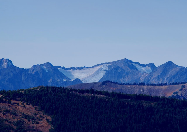
Carrie Glacier as seen from Blue Mountain.
Since about 1980, Olympic Mountain glaciers have been receding much more rapidly than in the past century. But Bill thinks that data gathering and analysis can help us manage better for the future and, hopefully, strive harder to reduce carbon emissions. (Dust off that bicycle!)

While Bill was off repairing a remote climate monitoring station near the Deer Park campground, I walked the Rain Shadow Loop trail at the summit of Blue Mountain, about a quarter-mile above. 

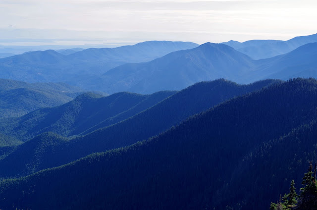
View west of Klahhane Ridge and Mt. Angeles, road to Hurricane Ridge is the hillside cut.


This short half-mile loop around the summit doesn't disappoint on a clear day. 

Okay, that's an understatement. Views up there are fling your arms wide, twirl around, and sing like Julie Andrews or shout in euphoria for the panoramic beauty of it all. (Which I didn't do because I was too busy taking a billion pictures...but I thought about it.) 

You can see north into Canada (Vancouver Island and B.C mainland), east to Cascade volcanoes such as Mt. Baker and elusive Glacier Peak, south deep into the craggy Olympic Mountains, and west up the Strait of Juan de Fuca.

South, (think) Obstruction Peak


Southeast

Eastward, Puget Sound visible in upper left.

Northeast, Mt. Baker (Kulshan) in the distance.

Tanker headed east on the Strait of Juan de Fuca.
Bill told me that this is about the driest place in Olympic National Park, protected by a rain shadow from the fronts that tend to come in from the south-southwest on the Pacific coast. (For more about the rain shadow effect in this area and updated weather info, check out the Olympic Rain Shadow website.)

Some of the lichen, plants, and trees up here don't generally grow west of the Cascade Crest, such as lodgepole pine (which, like glaciers, are threatened by climate change).


Yes, there are a few longer and more rigorous hiking trails that head into the park wilderness from here. But this is what I had time for, and it thrilled me just the same.

Happy trails and thanks for visiting Pacific Northwest Seasons! And I'd love to hear in the comments below about your Northwest experiences.

In between blog posts, visit Pacific NW Seasons on FaceBook, Twitter, and Instagram for more Northwest photos and outdoors news. 


When You Go
We're getting close to the end of the season to access Deer Park and Blue Mountain summit, but as of today the Deer Park campground was still open. From Highway 101 that runs along the northern peninsula, take the Deer Park exit just east of Port Angeles and head on up. When you reach the dirt road, you're within the national park boundary. It's 18 miles from Hwy 101 to the trailhead. Big rigs and trailers aren't recommended on the narrow gravel road to the top. 


Thursday, October 15, 2015

Lake Lillian: Rough Trail, Splendid Payoff


We humans were made to walk. And there's nothing quite so elemental yet rewarding as a vigorous hike through incredibly scenic alpine landscapes.  We've got plenty of that here in the Pacific Northwest, like the trail to Lake Lillian just a few miles east of Snoqualmie Pass.

Despite the beautiful destination and being just an hour east of Seattle via I-90, some rough sections of trail and an old (but regrowing) clearcut keep the crowds down on this trail.

On a chilly fall morning we begin hiking to Lake Lillian early, bundled in layers as we walk along the frost-covered trail. Within a mile or so we get high enough for views of the Big Guy to the south (who dominates much of western Washington).


Tahoma
In about two miles, just after we enter the forest past the clearcut, two tall, strapping young guys come scrambling quickly down the trail.

"Wow, you must have gotten an early start!" I exclaim in surprise, since they don't have backpacks for an overnight outing.

"We saw a bear on the trail ahead," one of them says. 

So should we continue? Heck yes! After all, there's an older couple ahead of us on the trail who haven't turned around.


Where's the bear?

if you read my post a few weeks ago about hiking in silence, on this hike we definitely are not silent. Just in case Mr/Ms Bear is still around, we talk and sing loudly as we hike on upward. (How many times can you replace a song's original lyrics with "bear"? Lots: Jingle Bear, Hey Bear, Rocky Bearcoon, You are my Bearshine....)

Fortunately we don't encounter anyone else on the trail for the next mile. My songs are silly, loud, and slightly off key. Maybe I scared the bear away with my singing.


At the 3-mile mark, the trail plunges steeply down through shrubs and reaches a flat where we find Twin Lakes, two idyllic alpine lakes very quiet on a still Sunday morning.


I'm enchanted by the cairn someone placed in the middle of one of the lakes. Because if you know me, you know I love cairns.


After stopping for several photos, we're off for the final push to Lake Lillian. 

Past another scenic little lake the trail rises steeply, then continues up, down, through a major rockfall, and along a final push so steep and in such poor shape that we think maybe we wandered off onto a game trail.


Nope. Just when we think about turning around, the older couple we saw at the trailhead is coming down.

"You're almost there, just over the rise," they tell us.

And indeed, in less than two minutes, here we are. Even better, we're alone at this splendid alpine lake.


With such strong contrast in the bright morning sun, it's hard to get some good shots of the amazing fall color on the far shore. Here's my try:


For the first 20 minutes or so, we're blessed with that particular quiet of alpine high country, with no one else here. A slight breeze barely ripples the lake surface. 

We look around for a trail around the lake, but after the rough trail up, don't feel like climbing hand over foot up the even steeper rocks that rim the lake. A couple adventurous guys, who arrived a bit later, do. But the guy on the right was very wary and moved slowly, with trepidation.


Within about 30 minutes, at least a dozen other hikers have arrived, and there's not much room to spread out without scrambling. Time to head back down.

"Down" isn't totally accurate. We probably gain close to 800 feet (or more) on the way back to the trailhead.

While heading back uphill on the way out, two other women pass us. Although I don't get her name, I'm in awe of the gal who only has one lung. She tells us she had a lung removed last year when they found a tumor. And on this hike I, with two healthy lungs, can't keep up with her. How inspiring is that woman? Mega.

So here's to all those who persist despite overcoming illness and injury. May you all be blessed with such tenacity and find your way to this and other beautiful trails.


Happy trails and thanks for visiting Pacific Northwest Seasons! And I'd love to hear in the comments below about your Northwest experiences.

In between blog posts, visit Pacific NW Seasons on FaceBook, Twitter, and Instagram for more Northwest photos and outdoors news. 


When You Go
According to the WTA website, this hike is 9 miles rountrip, with an elevation gain of just 2,000 feet. That's 2,000 hard-earned feet! You'll need a  Northwest Forest Pass to park at the trailhead. It's about 4 miles up a pretty rough dirt road a few miles east of Snoqualmie Pass on Gold Creek Road (north side of I-90).


Monday, October 5, 2015

North Cascades's Autumn Larches: Pure Gold

If you only do one essential Northwest outdoors experience (besides climbing a volcano) this fall, do this:

Call in sick tomorrow, hop in your car, and drive up the North Cascades Highway to Rainy Pass or Washington Pass*. Throw your Northwest Forest Pass on the dashboard, lace on some good trail shoes/boots, and hike up to Blue Lake, Lake Ann, or the Maple Pass Loop to revel in the golden larches at their glowiest, brilliant peak.

Pure magic.

The Rockies have their golden aspen, New England has all those gaudy maples, but in a narrow band of elevation, north-central Washington and southern B.C. have golden larches each October.

Set against a scoured glacial valley, towering cliffs, or alpine lake, they shimmer in the sun, glow in the foggy mist, and spin gold before your eyes.


A uniquely stunning tree, a deciduous conifer, the Lyall's larch (also called alpine larch) light up an October alpine landscape in their limited growing range

According to a University of Washington botany course, "Alpine larch occupies a remote and rigorous environment, growing in and near the timberline on high mountains of the inland Pacific Northwest."

So that means generally you have to hit the trail and climb to see them up close, to stand amongst a forest of gold far above the lowland maples.


*While Ingall's Lake in the Teanaway area of central Washington Cascades, the Enchantments near Leavenworth, and around Hart's Pass are epic larch destinations, they aren't as easily accessible as the hikes mentioned above along the North Cascades Highway.

I just hiked up to Blue Lake (one of the easiest larch hikes at 2.2 miles up and just over 1,000 feet elevation gain) yesterday for a stellar larch display. Generally the second week in October is when they peak, so you're probably good for another few weeks.

But don't wait too long.


Blue Lake

Because this is a sight that's truly enchanting and otherworldly to behold. It's sort of like seeing the unicorn of the conifer world.


I hope you can make it out there and catch this marvelous display. And if you can't, I hope my photos give you a vicarious sense of this gorgeousness.


Happy trails and thanks for visiting Pacific Northwest Seasons! And I'd love to hear in the comments below about your larch experiences.

In between blog posts, visit Pacific NW Seasons on FaceBook, Twitter, and Instagram for more Northwest photos and outdoors news. 

Wednesday, September 23, 2015

Quiet Time on the Trail

Have you ever tried hiking in intentional silence? 

Whether you meditate or not, taking that intention out into the woods or mountains is a powerful sensory experience. I guarantee you'll notice your surroundings with a sharper focus.

Every few months I lead a silent meditation hike somewhere out in the Cascade foothills within an hour or two of Seattle. 

We talk and laugh on the ride out and back, and sometimes stop for a snack afterwards. But when we start hiking, for the next few hours we refrain from conversation. 

Often we're wrapped up in our thoughts, but everyone is encouraged to just walk and take it all in as we go.


This past Sunday we were out hiking in silence on what was forecasted to be a blustery, wet afternoon. I considered cancelling, but everyone was game so we went anyway. Surprisingly it was calm and precipitation-free.

Where did we go?

Well...I seek trails that will be as quiet and uncrowded as possible relatively close to Seattle. So that means not divulging said uncrowded trails.


But it's beautiful and especially vivid without the distractions of smartphones and talking.

Every 30 minutes, we stop and sit beside the trail for about 10 minutes. Maybe we'll quietly nibble on snacks, sip water, put on bug juice, adjust our layers. But we sit without talking.


And get up and do it again.


And then sit again.


 And walk again. 


Just five minutes from the trailhead at the end of our hike, RIBBET RIBBET echoes through the surrounding forest. Tree frog.

Lush green moss-draped forest, sometimes muddy trail, gently flowing streams, slick wet stepping stone rocks, a slight breeze rustling vine maple leaves, resting on my sit pad on a damp log... all my senses are engaged.


Almost three hours after starting, we emerge from the forest surprisingly refreshed. At least that's how I feel afterwards. 


Consider joining us in the months ahead if you're in the Puget Sound region (link below). We try to go year-round, depending on the weather. Or try a hike with friends/family and make a pact to not talk for all or part of the hike.

You might be surprised what you notice.

Happy trails and thanks for visiting Pacific Northwest Seasons! And bonus points if you recognize the trail from the shots above. :)

In between blog posts, visit Pacific NW Seasons on FaceBook, Twitter, and Instagram for more Northwest photos and outdoors news. 


 When You Go 
Here's a link to the Blue Heron Zen calendar. The next hike isn't scheduled yet, but check back. I'm hoping to get something on the calendar for late October/early November. Forecasts are for a dry autumn 2015 here in the Pacific Northwest.


Wednesday, September 16, 2015

Road Tripping Southward: Into the Redwoods

While I've hiked many trails and traveled widely around the Pacific Northwest, until last week I'd never been along the Redwoods Highway in southwest Oregon/northern California. 

Wow. Just wow.

With most old growth Sitka spruce gone, the coast redwoods (Sequoia sempervirens) comprise the last significant remnants of what was no doubt mind-boggling forest magnificence along the Left Coast of North America.

Today only 5 percent remain of the estimated 2 million acres of the coast redwood habitat. Thank goodness for the Save the Redwoods campaign that began in 1918. 

For those of us so inclined, they are a sacred destination. Walking and sitting in the redwoods feels akin to being in the ancient cathedrals that I've visited in Europe, like a Chartres of nature.

I'm especially thankful for these trees, these ancient and magical forests, because on this particular trip they provided a perfect place to reflect on the life of my recently deceased, much loved brother.


With a couple days to get to San Francisco for my brother's memorial service, my sister and I make a mini-road trip of it, starting with an overnight in downtown Eugene, Oregon, at the pleasant and well-situated Timbers Motel.

After driving south the next morning on I-5 a couple hours to Grants Pass, we take the exit to Highway 199/Redwoods Highway and angle southwest through winding canyon country on into northern California.

And before we know it, we're amongst the big trees on a narrow, curvy roadway through Jebediah Smith Redwoods State Park, the northernmost in the Redwoods park complex.


Before this trip, I hadn't realized Redwoods National Park,World Heritage Site and International Biosphere Reserve, is actually a series of national and state parks strung out over 40 or so miles in the tippy top, northwest corner of California. The loopy road through them slaloms past a glorious panorama of the rugged Pacific Ocean coastline.


While we don't have time to explore and hike as much as I'd like, the ranger at the visitor center recommends a short hike through the woods in Prairie Creek Redwoods State Park along the 10-mile Newton B. Drury Parkway.  This side road off Highway 101 threads through giant redwoods closely bracketing the roadway. 


Our destination is the Zigzag Trail #1, connecting to the West Ridge Trail to Zigzag Trail #2, for a 3.2-mile loop. So the trailhead signs aren't well-marked and we didn't end up on the trail we expected; it was still a refreshing 90 minutes walking up and down through the forest.

Why they call them redwoods.
 
And because it's a healthy forest, there are diverse tree species.
After tramping for a while through a grove of huge old trees, past a stream and wetland, we reach a junction and head up towards the west ridge on this mild September afternoon.


Up here, with views into the rich forest below, around, and above, my sister decides to take a break and sit on a log beside the trail. As I join her, I suggest we sit in silence for a bit. Or maybe she suggests it, doesn't really matter.

What does matter is how incredibly powerful it is to just sit quietly in an ancient redwoods forest, listening, breathing steadily. I try to absorb the still, silent forest with all my senses.


For the briefest of moments I swear I feel the forest breathing too, then a slight breeze picks up. The mystic in me thinks immediately of our brother, whom we've both been thinking about and remembering as we travel to say goodbye in San Francisco.


Above in the forest canopy, a delicate, sweet bird call echos, and we rise to continue.

After cresting the ridge and not being sure which way to go (the directional sign points the opposite way our instincts tell us to go), an oncoming hiker comes along. Good thing; from her map we realize our instincts were right and we were on the wrong trail.

[Note to self: you know better than to hike without a map.]

So we descend, enjoying the truly awesome forest and big trees, so photogenic, as we go.


With gratitude to these splendid old trees and those who work to protect them. And may you, too, enjoy and feel their truly discernible presence. 

Happy trails and thanks for visiting Pacific Northwest Seasons!

In between blog posts, visit Pacific NW Seasons on FaceBook, Twitter, and Instagram for more Northwest photos and outdoors news. 


Good Eats Along the Way
Good eats in Eugene included tasty Thai dinner at the Ta Ra Rin Thai Cuisine and an inexpensive and quality breakfast at the Full City coffee shop/Palace bakery.

Based on a recommendation from Lonely Planet, we had delicious fresh halibut tacos for lunch at the Good Harvest cafe across the street from the marina in Crescent City, California.