Thursday, June 12, 2014

Hiking the Mountains to Sound Greenway: Marvelous Mt. Washington

With ever increasing numbers of happy hikers hitting the trails near Seattle, somewhere off the beaten path was our goal for a weekend hike. While local hiking guides declare Mt. Washington, with its unmarked trailhead and confusing junctions, as lesser traveled, I'm here to say...on a sunny Sunday, this hike is definitely discovered. Think overflow parking.

Nevertheless, it's a lovely hike with splendid views from the top. And there are fewer crowds on the trail than across the Snoqualmie Valley at Mt. Si and Little Si or nearby Rattlesnake Ledge.

Write-ups about Mt. Washington vary wildly in the distances for this hike, from  5.5 and/or 6.5 miles according to the Washington Trails Association (they contradict themselves) to 12 miles according to SummitPost.org.  My quads and knees told me about 8 miles round trip with an elevation gain of about 3,400 feet.


On an early June weekend, we start up the not-too-grueling but steady trail  through dense, lush second-growth forest on the lower mountain under a cover of low-lying clouds. (There's a trick to getting to the trailhead, but more about that below under When You Go.)

While there aren't views for much of the lower portion of the hike, at about 2 miles we stop for a view across the valley at the Owl Bench, tucked against one of the numerous rock walls along the route. With the clouds we can't see anything but white mist.

Owl Bench

A little ways farther we cross another clearing beneath a talus slope in a cleft of the mountain. We've ascended into the clouds by now and the view of misty forest, while I think enchanting, isn't panoramic.


After more than 90 minutes of hiking and still being in the woods, the two 11-year-olds in our group are getting hungry and tired (or more likely bored because they can run circles around us adults on the soccer field). So we plop down for lunch at a nondescript spot on the trail. 

Replenished, we continue on because descending hikers keep telling us about the glorious sunshine above.  Along the way I can't resist taking a few shots of the many lovely trilliums alongside the trail.


After about 3 miles we finally emerge from forest and clouds and begin traversing rocky scree/talus slopes and more scrubby alpine forest. Another half mile or so and we finally reach....an old logging/service road. 

I always get slightly peeved when I see someone can drive up what I've labored to achieve. But these days the only use of the road, if at all, is to service the cell tower at the summit. 

So we cross the road and push up another quarter mile or so to the top. Where, it appears, we're floating on an island above the clouds, amongst other snow-capped and craggy islands.


Mailbox Peak


A little rocky outcrop in a meadow area at the last switchback to the top is actually a much nicer place to stop, with splendid views of Mt. Rainer to the south. The summit above is another rock outcrop, but views are partially obscured by trees.

Rainier above the clouds.

 So we enjoy the sun, take lots of pictures, snack, and head down just as the cloud-sea starts dissipating.


Those 11-year-olds?  They chose to hang out at the wetland below and are radioing every few minutes impatiently asking when we'll be back down. When we do get back, they feign nonchalance about missing the visual feast on top. Or maybe they truly don't care. I don't know, it has been too long since I was 11.

On the way down, I notice a cave I missed on the way up that's a popular rock-climbing spot. If we didn't have two girls desperate for our post-hike ice cream stop at Scott's Dairy Freeze in North Bend, I'd have stayed and watch what this guy does.


 More people are coming up as we descend, and when we get back to the parking lot, it's full with overflow parking onto the access road. And a line at the bathroom, where I find myself standing in line behind the same woman who was in front of me in the same line 4 hours earlier.

Small world, huh?

Overall I give this hike two thumbs up. Good exercise, good views, gorgeous forest, interesting rocks and walls, and not as crowded as other nearby well-trod trails.

Have you done this hike? Would love to hear how it was for you or about your favorite hikes in the comments below.  Happy trails and thanks for visiting Pacific Northwest Seasons!

When You Go
To get to Mt. Washington from Seattle, drive east on I-90 to exit 38. Head south (right), immediately crossing the South Fork Snoqualmie River, and take the first right turn into Ollalie State Park, a few hundred feet from the highway. Follow the gravel road to the end, parking near the bathrooms at the end of the lot.


Start at the short spur trail up to the John Wayne Trail/Iron Horse Trail near the end of the parking lot by the bathroom. Stay right at the junction, continuing to climb uphill for another tenth of a mile, and stay right at the next junction with the John Wayne/Iron Horse Trail—a wide gravel road. In a few hundred feet, head south on the second trail into the forest, 0.3 mile from the trailhead, marked by a small rock cairn, the start of the Mount Washington Trail. True, there are several junctions along the trail, but I didn't they were confusing.


Tuesday, May 27, 2014

Sucia Island Kayaking, Camping, and Hiking

Ewing Cove
Northwesterners play outdoors year-round, but the longer days of late spring/early summer really pull us outside.  Who needs a triple latte to start the day when it's light from 5:00 a.m. until after 9 p.m. and the skies trend more blue than gray? A perfect destination to start (or finish) the camping season is Sucia Island State Marine Park, which lies just north of Orcas Island in Washington's San Juan Islands.

Throughout the summer and into the early fall, Sucia is a very popular place
—a little too popular on a nice weekend. Regardless, the park (which also encompasses numerous small islands/islets) is big and varied enough to handle many campers/boaters.

On a peak summer weekend I join a trip with the Seattle Area Sea Kayaking Meetup Group to kayak over and camp a night on Sucia, my second kayak trip there. After the alarm wakes me up at zero-dark thirty for the 80-minute drive from Seattle to Anacortes, we catch an early Saturday morning ferry over to Orcas Island. As any Puget Sounder knows, ferry lines to the San Juans on a summer weekend can backup for hours.

Our destination on Sucia is Fox Cove, a protected bay on the southwest side of the island, with a generous wide, sandy beach for landing. We park and launch from North Beach on Orcas for the 2.5-mile crossing under cloudy but clearing skies and a light breeze. 


Image courtesy of the U.S. Geological Survey


Sucia Island ahead

In about an hour we pull into Fox Cove and find a few campsites on the isthmus between the cove and Fossil Bay.  Fortunately for us a group is just pulling up stakes and leaving. However, it's not exactly quiet and secluded. Lots of groups and families have filled up the many campsites tucked in the woods and open areas here.

Fox Cove looking toward Little Sucia Island

Since we arrive early, our group goes for a hike after setting up camp. A network of trails (10 miles total) passes through forest, lovely coves, and intricate and unusual sandstone formations.  The western/southern part of Sucia is composed of 80-million-year-old seabed that drifted north from Baja California, in contrast to the eastern/northern part that's part of the Nanaimo formation found in Canada's Gulf Islands and Chuckanut Sandstone from western Washington.

"Ghost" forest on Shallow Bay
 For our 4-mile trip out and back from Fox Cove, the turnaround point is on the north side of Echo Bay.  On the way back, a few of us scramble around some sandstone because, well, it just looks fun.

Echo Bay, North and South Finger Islands

 I couldn't resist


After dinner, the conditions are splendid for a sunset paddle along the western side of the island. Calm seas and just a few clouds make for a spectacular evening.


With such an early morning and active day, we all drift to our tents not long after dark (which is around 10 p.m.), only to be awakened by a crying child at a nearby campsite a few hours later. Not much solitude at the bigger campsites on a summer weekend.

Before heading back to Orcas on Sunday, we paddle out to magical Ewing Cove at the northeastern part of Sucia.  This morning we head south and east around the island, passing dramatic shoreline rocks.


Southern shoreline of Sucia

Enroute in Echo Bay, we're briefly surrounded by several shiny dark harbor porpoises that pass so close I could reach out and touch them with my paddle. They don't seem to mind us.

Ewing Cove and the surrounding small islands are a popular area for all sorts of kayaking tours and trips. Personally I most enjoy kayaking along and around small scenic islands, and here there are plenty.

Some passages can't be negotiated at low tide.

Ewing Cove
Because this is a one-night trip, we reluctantly pack up and head back to North Beach on Orcas by mid-afternoon. During the crossing on placid and calm sea, a big dark something barely surfaces several times perpendicular to our line of travel. We know we've seen a whale, and ultimately the best guess is a minke.

A one-nighter is not enough time to thoroughly explore Sucia, but it's a good start.  The ex-pat Russian family camped next to us had been there all week.

Have you been to or camped on Sucia? We'd love to hear about your trip in the comments below.  Happy trails and thanks for visiting Pacific Northwest Seasons!

When You Go
Sucia is of course only accessible by boat, and various outfitters offer day and longer trips there.  Here's a link to a water taxi to Sucia in the summer season. Many go there via private motor boats, sailboats, and sea kayaks.  Click here for information on reserving one of the 60 campsites in the park.  Here is a link to a few Washington Trail Association trip reports about hiking the island.


Tuesday, May 13, 2014

Hiking the Columbia River Gorge: Heavenly Angel's Rest


Due to the extensive fire that raged through the Gorge in September 2017, the Angel's Rest Trail is still closed as of April 2018. Trailkeepers of Oregon are organizing work parties to begin to work on this trail, next one will be 4/14/18. Check out their page to sign up.

Walking and hiking in the western Columbia River Gorge  always makes me feel euphoric.  All that lush, intensely green vegetation, trees, and wildflowers! That sweet, moist fresh air! 

Abundant with coursing streams and waterfalls, the Gorge boasts a crazy profusion of plants and trees, some not found anywhere else in the world.
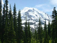
And then there are the views.  

Since scrambling around the  Gorge as a teenager, I've hiked all over the globe. But I still get excited any time I hit a trail in the Gorge. When I went up to Angel's Rest last weekend, I had to wonder a few times if I'd ended up in Heaven—at least my version of Heaven.

Surprisingly, it's my first hike up to Angel's Rest, about 4 miles west of Multnomah Falls. Or maybe this hike has blended together in my memory with many hikes I did as a teenager.

Dead tree snag leftover from 1991 fire.

Regardless, Angel's Rest is an extremely popular and splendid hike, just 45 minutes from downtown Portland. I get to the trailhead around noon on a cloudy Saturday and find a parking place close by. Perhaps the threat of rain is keeping the crowds down.

For the first half of the 2.4-mile hike up, the trail meanders, then switchbacks upwards through forest dense with underbrush, crossing Coopey Creek and providing peek-a-boo views of Coopey Falls and then the Columbia River.


Can you say green?

After gaining more elevation, the trail crosses an old rockfall and later emerges into the burned area, with even better views.


Columbia River Basalt cliffs across the Columbia River in Washington.


And before I know it, I've reached Angel's Rest, where columns of aging basalt look like  teetering stacks of pancakes along the spine and edges of the bluff.
Northwest view


View north

Other hikers have plopped down atop various rocks, but I'm spinning around, taking in the view. The edge of the 1991 fire is still very visible, separating more mature forest and thriving new growth.

View south
View westward, downriver
View eastward, upriver
View DOWN
With a rain squall moving visibly downriver toward us, I scoot over the sometimes rocky trail that leads to the prow of the bluff. A few others are here already, but more and more hikers are coming up behind me.

Rain approaching


Although the top of the bluff is thick with shrubs like serviceberry, I still step carefully.   It's a long way to fall. I would not want to be up here on these weathered old rock formations during an earthquake.


On the way down I pass plenty of hikers headed uphill, in everything from light sneaks and tank tops to heavy-duty hiking boots and REI-wear.  This being close to Portland, I even pass a hipster hiker wearing leggings and a skirt. Be forewarned, even in dry weather the trail can be rocky and muddy in places.


While my goal was to be up and down in three hours, it stretched to four. This hike is just too beautiful, there were too many photos to take, and too much exuberant foliage and waterfalls to be savored.

Have you hiked to Angel's Rest? Any special memories there? What is your favorite hike in the Gorge? Would love to hear in the comments below. Happy trails and thanks for visiting Pacific Northwest Seasons.


When You Go
The hike to Angel's Rest is just under 5 miles round trip and considered moderate.  It's not that steep but a steady grade of uphill for about 1,400 feet. Eastbound on I-84, take Bridal Veil Exit #28. The trailhead is on the south side of the historic Columbia River Highway, opposite the junction with the interstate access road in Bridal veil. From westbound I-84, take Ainsworth State Park Exit #35 and follow the historic Columbia River Highway for 7.1 miles (11.4 km).  An alternate, more scenic eastbound route is to come down from the Corbett area via the historic Columbia River Highway, with stops along the way at Chanticleer Point and Crown Point/Vista House.


Sunday, May 4, 2014

Cape Flattery: Drama at the Continent's Edge

At the remote upper left hand corner of the continental United States lies a pilgrimage trail that calls to the adventurous and those stalking wonder.  

The lovely Cape Flattery trail winds through the forest to a series of five dramatic overlooks. When you arrive, stand on a platform overlooking a precipice at the northwestern-most point of the Lower 48 and watch the roiling Pacific ocean in all its power and beauty. With ocean-cut sea stacks, colliding cross-current waves, and a constant breeze, the views here are always breathtaking.


Although I've been to Neah Bay on the Makah Reservation, this is my first time hiking out to the point at Cape Flattery. When I was younger this was a much more rugged hike, but thanks to the Makah Tribe, a new trail was installed in  2008 with boardwalks over the muddiest portions and safe viewing platforms near the point.  


After driving to the end of the road on Cape Flattery above Neah Bay, we park  at the trailhead.  Then it's an easy walk down through a forest kept rich green by frequent drenching rains off the Pacific.
Skunk cabbage in bloom.


About 3/4 of the way down the 3/4-mile trail, the ocean to the west and the Strait of Juan de Fuca to the north come into view through the woods.

Looking northeast toward the Strait of Juan de Fuca, Vancouver Island in the distance.
 Here wind and currents combine and collide in showy displays of splashing waves and rough seas. These headlands and cliffs are being pounded and eroded away by the sea.


While we're blessed with blue skies today, this would be a stunning place to visit in any weather.  The view below is one of the many reasons I'm so passionate about my homeland.

View west-southwest to the Pacific Ocean

On an April weekday, we don't see many others on the trail, but with the renovated trail and newly paved road, more visitors are making their way here.  Today we find a few birders from Whidbey (Island) Audubon at the point, who let us look through a spotting scope at some huge Steller sea lions on a rocky outcrop offshore. 

Because I can't resist, I sneak around the platform to touch the northwestern-most tree in the contiguous U.S.  But just for a second because it's not a safe or smart thing to get too close to the cliff edges off the trail.

Kids, don't do this...


Lighthouse on Tatoosh Island.

This place holds special meaning for the Makah, who have lived in the area for thousands of years.  Tatoosh Island just offshore was a fishing camp for the tribal whalers and fishers, was a Coast Guard station (now decommissioned), and is the subject of several decades of ongoing biological research showing alarming changes likely related to climate change.

For now I put aside concern for our oceans and marine wildlife and just enjoy the beauty all around. Currents here boil and smash together as water rushes in from the Pacific and out from the Stait of Juan de Fuca, creating some impressive sprays.


It's hard to tear ourselves away and head back up the 300 feet we descended from the trailhead.  A few weeks later I'm still carrying the wonder and thrill of seeing this unique and stunning place.

Have you been to Cape Flattery? Before or after the new trail/road was installed? Would love to see your comments below. Happy trails and thanks for visiting Pacific Northwest Seasons!

When You Go
Neah Bay is about 160 miles northwest from Seattle on the almost-northwest corner of the Olympic Peninsula.  Click here for directions to the trailhead from Neah Bay. A Makah Recreation Pass must be purchased in Neah Bay prior to arriving at any trailheads on the Makah Indian Reservation.  

While in the area there are several other things to do/see since the hike out to Cape Flattery only takes an hour or two out and back. For a short side trip after you come back from the Cape trail, cross over the Waatch River to see Hobuck Beach and Shi Shi (pronounced shy shy) Beach. Also the Makah Museum in Neah Bay is worth a visit.