Tuesday, October 8, 2013

Hiking to Mason Lake: Spectacular Views and Fall Color

With its southern exposure, the Ira Spring Trail to Mason Lake and Bandera Mountain is a perfect place to hike magnificent alpine scenery early and late each year when snow lingers elsewhere.
On a bluebird fall day when the vine maples are near their peak of scarlet brilliance, this trail just west of Snoqualmie Pass near Seattle is especially stunning. When it emerges above the forest into the open slopes below Bandera Mountain, the boulder-strewn mountainside above is splashed with patches of crimson, orange, gold, and forest green.

We luck on such a day this past weekend when a hike to Lake Ingalls was cancelled due to heavy snow on the trail. So we miss the golden larches, but we get a stellar display of vine maples and other shrubs instead. I say that's a decent trade-off.

Besides all that fall color, there are stunning panoramas of Mt. Rainier to the south and  the Olympic Mountains farther to the weststriking reminders of our active regional geology here in the Pacific Northwest.


Mt. Rainier looms large to the south from the Ira Spring Trail.

Of course we're not alone on a beautiful day when there's snow at most of the higher alpine trails in the Cascades.  After driving a few miles off I-90 on a dirt road and dodging some impressive potholes, we manage to find a parking space at the outer edge of the parking area. Get here fairly early on weekends to find a spot; otherwise you'll be parking a ways down the road.

While the first mile or so is an easy stroll through forest along an old road grade, the trail steepens when it loses the road and switchbacks upward.

Treading gingerly across Mason Creek
I keep asking my hiking buddy Julie, who hiked here more recently, if each boulder field we cross that windows onto the valley below is "the" boulder field she says is ahead.

"Not yet." she replies.

Looking west down upper Snoqualmie Valley and I-90 corridor.


Based on the heavy snow last week (skiing at Crystal Mountain even!), I dressed for cool weather and packed a thermos of hot tea.  When we do break out of the forest into the upper boulder fields, I shed as many layers as possible and gaze in envy at others on the trail in shorts and T-shirts. 


At 2.8 miles along and well into spectacu-land, we reach a junction with a sign for Mason Lake (left) or Bandera Mountain (right).  I'm very tempted to continue up to the mountaintop for even better views, but today we're both feeling a bit rusty and stick with the original plan:  Mason Lake. So we head left.


The road not taken:  upward to Bandera Mountain summit
We angle a quarter mile up to the ridgetop and then drop down about 300 to 500 feet in elevation (sources differ) through forest to Mason Lake. We share the trail with Chris, a friendly medic who volunteers for the U.S. Forest Service and knows the trails around here well. (Big kudos to Chris and others who donate their time and expertise helping rescue lost and injured hikers.)


Nearing the ridgetop, Mt. Defiance summit just beyond


As we drop down behind the ridge, we enter a different ecosystem of moss and fungi compared to the sun-drenched southern exposure on the other side. 

 After finding a spot on a big boulder to park beside the lake, we relax for a while at this lovely alpine cirque. Reflected sunlight sparkles like diamonds flung across the dappled water surface, and it feels a world away from Seattle just 50 miles west. 


Bandera Mountain's snow-dusted summit rises high above the opposite lakeshore, where I spot a few hikers way up there.


On our way back down, we pause to drink in the view at the ridgeline above Mason Lake.  If we're lucky, we'll have more glorious fall days like this for hiking, but the odds are against another warm day like today in October.


As we're descending, trail runners pass us along with clumps of students from the University of Washington, members of a climbing club who've just descended Mt. Defiance beyond Mason Lake as a training hike. I used to feel the need for speed when hiking, but these days I try to savor the experience unless I'm racing the weather or darkness. 


This is a hike worth savoring.

When You Go              
According to the Washington Trails Association, it's a 6-mile round trip to Mason Lake from the trailhead, with an elevation gain to the ridge top of 2,550 feet. You gain another few hundred feet when you hike back up from the lake.  This an easy-medium hike; it starts out very mellow along the old roadbed but does get a little steep on a few of the switchbacks. However, the trail is very well-maintained, thanks to WTA volunteers. And of course it all depends on your conditioning. Don't forget your Northwest Forest Pass, which is required to park here.

Driving Directions                            
From Seattle drive east about 50 miles on I-90 to exit 45 (Forest Road 9030). Drive north, then stay left on FR 9030. About 1 mile from the freeway, you'll encounter a fork. Stay left again, now on Mason Lake Road (FR 9031). At about 3.9 miles from the freeway, park where the road is blocked--the road continues on the other side, but only for foot traffic. There is an outhouse at the trailhead, but bring your own TP just in case; there was no toilet paper when we were there a couple days ago.


Friday, September 27, 2013

Fall Colors in the Pacific Northwest

Autumn is my favorite time of year, when deciduous trees look like they're all dressed up for a pre-winter party. While we don't get quite the showy fall colors here in the Pacific Northwest that New England does, we do get some spectacular displays. 

It's still early in the season, but many trees are already starting to turn.  Here are some general suggestions of where to see leaves turning here in the Northwest, but I'd love to hear your suggestions too.

Ornamental maples planted around Portland, Seattle, Eugene, Spokane, and other Northwest cities can be brilliant.  For example, at the peak of color in later October, just drive down Holman Road from Greenwood Avenue to Crown Hill in Seattle when the trees lining the street are crimson red. Stunning!


Ornamental maple leaves, Joseph, Oregon

In Seattle's Carkeek Park in late October, these two trees pictured below near the salmon slide are at their peak. You'll no doubt find other colorful trees around our cities and towns.

In Seattle's Carkeek Park
 

Our formal Japanese gardens are splendid  in the fall when the Japanese maples turn:  Try the Seattle Japanese Garden at the Washington Park Arboretum, the Portland Japanese Garden in Washington Park above downtown, and the Bloedel Reserve on Bainbridge Island.

Bloedel Reserve

Big-leaf maples (the "king of the Northwest woodland") predominate here west of the Cascade Mountains. I remember driving past what looked like a wall of brilliant gold big-leaf maples on a crisp fall day in the Columbia River Gorge east of Portland on I-84.

There's a reason this tree is named big leaf.  Some of the leaves can get huge, upwards 10 inches in diameter.  When they fall, they really carpet a trail.

Big-leaf maples along a trail in Carkeek Park

On another trip along the Columbia River on State Route 4,  part of the Lewis and Clark Scenic Byway, the abundant big-leaf maples made an otherwise gray Northwest day bright with hues of yellow and gold. This route in southwest Washington just across the river from Oregon is lovely any time of year as it winds past charming and historic places like sea kayaking destination Skamokawa.

Big-leaf maples, Joseph, Oregon
Where our fall color really shines is at higher elevations in the mountains.  Native vine maples are a highlight, turning scarlet orange in late September into October.

Along the Snow Lake Trail, Alpine Lakes Wilderness
If you can catch a dry day in the fall, go hiking in the Cascades or Olympics for brilliant fall color at shrub level.  Native huckleberry plants leave slashes of vivid gold, scarlet, and orange all over meadows and slopes.  A particular favorite hike of mine (and many others) is the stunning Naches Peak Loop Trail at Chinook Pass in Washington, which also offers breathtaking views of Mt. Rainier just to the south.


Along the Naches Loop Trail

For a uniquely Northwest twist on fall colors, continue east of the Cascade crest for spectacular views of golden larches in mid to late October.  According to trail guide book author Craig Romano, who grew up in New Hampshire, "The larches are the next best thing to New England hardwoods when it comes to autumn foliage.”

Golden larches along the road to Hell's Canyon overlook, Wallowa Mountains, OR

Alpine Lakes Wilderness is a great place to see these deciduous conifers from the trail, but you can also enjoy them from the car on a drive over Chinook Pass and other parts of the region, such as in the Blue and Wallowa Mountains of southeast Washington and northeast Oregon.


Golden larches starting to turn, east of Chinook Pass


In the eastern crest of the Cascades and high and dry country of eastern Oregon and Washington, quaking aspen also turn shimmery gold in the fall.  If you can take the time, try heading to the remote Steens Mountain area in southeast Oregon for a good aspen show. I've also enjoyed seeing them in the Pasayten Wilderness in northern Washington.


Along the Naches River, late October
These are just a few of many, many places to enjoy our fall color here in the Northwest.  Where are your favorite places or hikes to enjoy the peak of autumn as the leaves turn? Jump in with a Comment below!

Happy Trails and thanks for visiting Pacific Northwest Seasons.

Fall is here! September 26, 2013, in Seattle.


Monday, September 16, 2013

Five years of Pacific Northwest Seasons: A Sense of Place


Five years ago today my first blog post appeared here at Pacific Northwest Seasons. That's 222 blog posts (including today) and a lot of everyday adventures here in the Northwest. Can it really be that long ago?
My primary goal is to inspire you all to get out and enjoy this quirky, beautiful, and unique corner of the world, with an eye to protecting its environmental treasures.

But really it's also about cultivating a sense of place, embracing where we inhabit and live. 

I've been inspired by a lovely, lyrical, and quiet book I read years ago called The Island Within by Richard Nelson, about what it means to really claim the place one lives--and to allow onself to be claimed by it. To quote Nelson:


My hope is to acclaim the rewards of exploring the place in which a person lives rather than searching afar, of becoming fully involved in the near-at-hand, of nurturing a deeper and more committed relationship with home, and of protecting the natural community of all who live there.

Those words struck a deep chord within me as I read it far from home, on a beach in Costa Rica. I do love to travel the globe, but that book made me more thoroughly recognize the worth of spending time closer to home as well.

So now that I've lured you in with a glamour shot of Mt. Rainier, I'm sharing a series of photos of a stretch of trail in the woods at Carkeek Park near my home in north Seattle, where I walk regularly. Some are taken on my smartphone, so the image quality varies.


 February
Maybe it's because I was raised in the woods next to a lowland forest, where I roamed for hours as a kid, but I need to get out in the woods regularly.  My walks in Carkeek are as much for spiritual and physiological nourishment as physical exercise.  

 March
 So a year or two ago I started snapping photos near the same spot on the trail, to bear witness to the place as it changed throughout the year.


 April
In the April shot above, notice the delicate bleeding heart flowers in bloom on the bottom right just off the trail.


May

May
By May the salmonberries have really leafed out. What a difference a month makes. The fresh spring green and lushness is at its peak of the year from now into June.


July
By September things are starting to look a bit tired, and a few leaves are starting to turn yellow and drop.


September
October into November bring down the big-leaf maple leaves, which carpet the trail in hues of gold and brown. This is my favorite time of year.


November
All I'm missing is a December or January shot with a blanket of snow. But as most of you know, we just don't get regular snow here in the lowlands of western Oregon and Washington.

When I loop out of the forest above Puget Sound on my walks, I have a ritual of always going down to the shoreline and touching the saltwater as it laps the beach in usually gentle waves.


Sometimes I'm lucky and spy a seal swimming offshore, bald eagles or osprey hunting for fish, or great blue herons combing the beach for food.


I could post a zillion shots I've taken on my Carkeek walks, but the point is this:  I come down here to feel a sense of place, a more natural sense of the seasons in the forest and at the adjacent beach near my home, beyond my built-out neighborhood with side-by-side houses.

I hope you, too, embrace and feel connected to the natural world wherever you live, whether it be the Pacific Northwest or not. Do you have a favorite place near your home that draws you back throughout the year?

 Thank you for visiting my blog. I hope you enjoy it and maybe even are inspired by it. And I always appreciate when you leave a comment below.

Happy trails from the Pacific Northwest.


Puget Sound sunset, Carkeek Park beach


Monday, September 9, 2013

Kayaking Seattle: Through the Ballard Locks and Back


Seattle and the Puget Sound region are blessed with many scenic sea kayaking destinations, but I think the most unique is a trip through the historic Hiram M. Chittenden (Ballard) Locks. Some say you haven't really kayaked Seattle until you've done this quintessential Seattle boating experience. 

The Ballard Locks, which are listed on the National Register of Historic Places, are a part of the region's maritime history but of course are still operating as they have since 1916. They consist of a series of concrete "locks" that maintain the water level of freshwater Lake Union and Lake Washington to the east while boats pass through from Puget Sound.  

On a recent late summer evening I joined several people from the Seattle Sea Kayaking Meetup Group for a paddle from Salmon Bay in Ballard to West Point and back. What a great way to spend an evening after a day sitting at a desk in front of the computer!

We meet at 6:30 at the 14th Avenue NW boat launch, two blocks south of Trader Joe's, and start paddling west past industrial-becoming-sorta-gentrified Salmon Bay boats and houseboats.

Passing waterfront digs, Salmon Bay in Ballard

Heading west under the Ballard Bridge

 As we near the locks, our trip organizer Lara tells us to hold up and wait for instructions over the PA system at the locks.

Waiting outside the east side of the locks.
 "When you get inside the locks, grab a hold of the wall or a kayak next to you that's against the wall, and hold on tight," she says. "When the water drops, the hydraulics are strong."

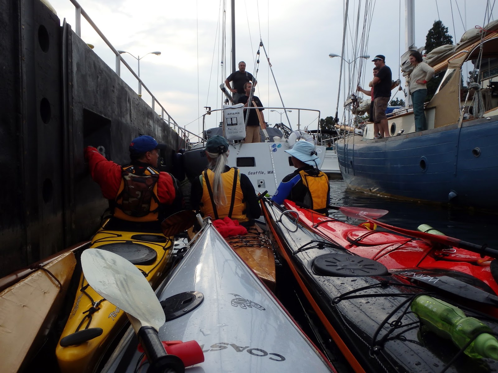
I do what I'm told. Pretty soon the locks operator instructs us kayakers to enter, and we squeeze in behind larger craft (like that gorgeous blue wooden sailboat to our starboard). And then I grab the kayak beside me that's next to the wall and hold on.  

It feels a little like a party in the locks.
 
When the water drops and the locks open westward, the pull of the incoming water is indeed strong for a couple minutes. I really do have to hold tight to the kayaks on either side of me.

Then it's a beautiful, windless evening as we paddle out of Shilshole Bay past residences on the south in Magnolia and restaurants and condos on the north.  Soon we're out in the Sound angling along the shoreline of Discovery Park toward West Point.


Nice beach on the north side of West Point.
 We all land at the smooth sandy beach just north of the West Point lighthouse and enjoy snacks that a few have brought to share.  It's a Mexico meet Europe theme, with chips and salsa, beer, and good cheese and Toblerone chocolate. In this setting, anything would taste great.


With the days getting noticeably shorter than earlier in the summer, we head back to Ballard as the sun starts a quick slide down to the Olympic Mountains on the western horizon. By the time we get back into Shilshole Bay, it's fast becoming dark.

For about 10 minutes or so we just hang in the bay outside the locks, waiting for our instructions to enter.  

In Shilshole Bay calm.
 
Looking directly at the locks.  Watercraft enter and exit on the left.

As we paddle east back through Salmon Bay in the dark, it's like passing through an altogether different, enchanted world within the city, rarely seen by those of us who don't live on the water. I didn't realize how many people lived on boats at the south end of Ballard.

Around 9:30 we arrive back at the boat launch, a bit late for pizza afterwards since it's a week night. But that's okay.  I'm refreshed after this evening on the water, and our trip through the locks added an extra spice of adventure.

When You Go
The Seattle Sea Kayaking Meetup Group is actually having another evening paddle through the Ballard Locks on Thursday, September 12, although the trip is already full. If you decide to take a kayak through the locks, please pay careful attention to the lock operator's instructions over the loudspeaker. And if you paddle at night, bring a headlamp or other lights to make yourself visible on the water.