Tuesday, June 30, 2015

Saving Olympic Peninsula Salmon: Upper Quinault River Restoration

With dramatic dam removals, the Elwha River restoration on the northern Olympic Peninsula has gotten worldwide attention. Did you know that an equally important, long-term salmon habitat restoration project is also underway across the mountains on the upper Quinault River?

"This is one of the largest river restoration projects in the western U.S.," says Bill Armstrong, the Quinault Indian Nation Habitat Management Scientist and Lead Entity Coordinator for the project. "It's a very large, very complex project."

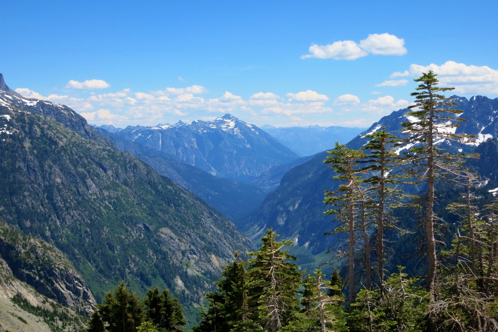
Known for its prized blueback (sockeye) salmon run that might have numbered over a million fish on a peak year, the Quinault River has for millenia been a culturally and economically significant fishery for  peoples of the modern-day Quinault Indian Nation (QIN). With glaciers melting that feed the river, water temperatures rising, previous old growth logging along the river, and large wood removal from the river (among other issues), Quinault River salmon have been rapidly declining since the 1950s.

In 2005, a scientific investigation of the river by the QIN concluded that intervention would be needed to rehabilitate the river, floodplain, forests, and salmon habitat. According to QIN President Fawn Sharp, who spoke at a public meeting at Lake Quinault Lodge last week, "We need collaborative intervention."

Fortunately, a team of scientists, engineers, and even loggers are now collaborating to restore the upper Quinault River, based on innovative concepts laid out in the QIN's 2008 Upper Quinault River Salmon Habitat Restoration Plan

Project team members: Forest ecologist Michael Mazzacavallo, logger Bruce Lutz, forest ecologist Dr. Kevin Fetherston, engineered logjam designers Deb Stewart and Leif Embertson, and lead entity coordinator/habitat management scientist Bill Armstrong.
Without going into too much detail, most of the former 55 miles of extensive side sloughs and channels where salmon spawn have disappeared since the mature conifers were logged along the river. Without large trees falling into the river to divert the river into side channels, the mostly cobbled, barren floodplain provides little refuge for salmon and the river moves across the floodplain, eroding the riverbanks.

North Slough, one of the few remaining side channels in the upper Quinault River.
However, since 2009 numerous engineered logjams have been constructed on the river to mimic natural logjams and encourage the river away from shorelines and into side channels. More are planned.


Two engineered logjams on the upper Quinault River.
"We're working to mimic Mother Nature," explained forest ecologist and Floodplain Restoration lead Dr. Kevin Fetherston at last week's public meeting on the project.

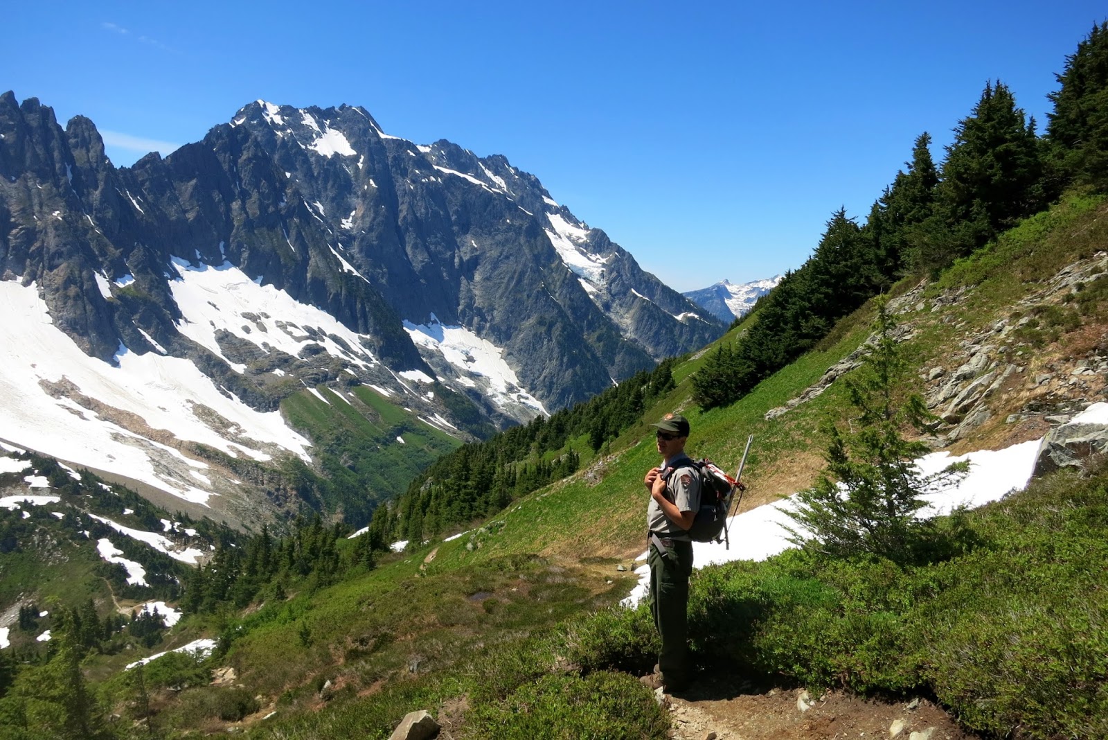
Before the meeting last week, I spent a day in the field with Kevin and his fellow scientist Michael Mazzacavallo while they conducted scientific monitoring of recent Sitka spruce plantings on the upper river floodplain. For this word geek whose work involves sitting most of the day in an office, it was a refreshing change of pace, despite the bug bites, heat, and wet feet from wading through the river and side channels.  

Trying to keep up with the scientists while making our way to a monitoring site.
Just this past spring, about 12,000 Sitka spruce seedlings were planted along the north side of the river in the floodplain, amongst what is now mostly alder forest. The ultimate goal is to create a natural forest succession, where the deciduous trees like alders are ultimately replaced by mature conifers that used to naturally occur in the Quinault floodplain. Sitka spruce are the most shade-tolerant, so they are planted first.


Map of floodplain showing different floodplain forest restoration treatment approaches and monitoring locations.
Kevin's and Michael's task was to locate several monitoring locations in the tree-planting areas and gather various data. Clipboard in hand, Michael ran through a checklist of items for each site, such as sampling the soil types, taking photos of the seedlings and forest canopy, checking site characteristics, checking and tagging seedlings, assessing the surrounding vegetation, and more. 

Michael Mazzacavallo and Dr. Kevin Fetherston discuss and log site data.


In addition, "We're not just monitoring, we're getting more data to answer more questions,” Kevin told me, such as how the seedlings grow under different conditions at each site. They're installing permanent markers in the ground at each site that will allow others to gather the same data 100 years into the future. 

Sitka spruce seedling, doing well so far.
 "Is there something I can do to help?" As long as I was there, I figured I might as well make myself useful. Michael handed me eight thin metal stakes topped with a white flag and asked me to find and mark eight seedlings within about a 15-foot radius of the monitoring site marker. It was like a Where's Waldo game in the thick underbrush.

In the afternoon we were joined by Debbie Preston, Information and Education Officer of the Northwest Indian Fisheries Commission, who has followed and written about this project since its inception. Mid-afternoon when the wind picked up and branches occasionally crashed to the ground around us, Kevin decided it was time to pack it in for the day.


A good crowd from the surrounding communities gathered in the evening at Lake Quinault Lodge for an update on the project, hosted by the QIN. President Fawn Sharp spoke for a few minutes to start, and her enthusiasm and concern for restoring the upper Quinault River are evident. In turn, several of the key scientists, including Lead Entity Coordinator Bill Armstrong, Leif Embertson who designed the logjams, Dr. Kevin Fetherston, and Dr. Brian Winter, gave status updates on the various project components.

Dr. Kevin Fetherston discusses floodplain forest restoration at a community meeting.
What's evident to me as an outsider is that several years in, the local community seems pretty much behind this program. One man voiced frustration that restoration on Finley Creek, a tributary to the Quinault River, hasn't begun  as quickly as the upper Quinault restoration.

But in reality, although things are happening now on the upper Quinault, this is a very long-term project (possibly up to 50 years), with ongoing efforts by the QIN to secure state, federal, private, and tribal funding. Even 100 years from now the upper Quinault River restoration will still be in progress, albeit naturally. 

Restoring the river that produced "arguably the single most famous salmon run on the Pacific coast of North America," according to author Bruce Brown in his powerful book Mountain in the Clouds, will take time. Many trees that formerly anchored the floodplain were hundreds of years old, some possibly as big as the tree pictured below just a few miles downriver on Lake Quinault.

One of the two world's largest Sitka spruce, on the shore of Lake Quinault.
I'm heartened that the QIN is looking ahead and leading this effort now, with climate change concerns looming for salmon. I wish I could live to see big older conifers growing again along the river. But I'm glad to know that they will be there in the centuries ahead.

For more information on the Upper Quinault River Restoration, check the Northwest Indian Fisheries Commission newsletter or the Quinault Indian Nation website. If you'd like to support this project, think about donating to some of the nonprofits who are project partners: Pacific Coast Salmon Coalition, The Nature Conservancy, and Trout Unlimited.


Friday, June 19, 2015

Hiking North Cascades National Park: Cascade Pass and Beyond

Way up north in the upper left hand corner of the U.S., wild and dramatic North Cascades National Park bumps up against the Canadian border in northern Washington. It's one of the largest wilderness parks in the U.S. but one of the least visited. 

Lucky for us.

However, the trail to Cascade Pass and up Sahale Arm is the most heavily used in the park, for good reason. Before you even hit the trail at the end of Cascade River Road, the scenery is spectacular, with jagged, glacial-scoured peaks thrusting straight up to the sky just beyond the parking lot.

I'm lucky to be hiking up the trail towards Sahale Arm with park trail crew leader Luke Daquila, who's going to show me recent trail repairs and where more are planned for the summer ahead. (See the blog post about this at the Washington's National Park Fund website.)

On this absolutely brilliant bluebird day, which happens to be a weekday, the parking lot is pretty empty. Expect overflow parking on summer weekends.

I follow Luke up the trail, which for most of the way up to Cascade Pass switchbacks at a relatively mellow grade through scrubby forest with peek-a-boo views of the surrounding peaks.

A lot of this...
"This is the steepest part of the trail to the pass," jokes Luke as we scramble up a few feet of a not-steep patch of trail soon after starting. 

He has counted 37 switchbacks up to the pass ("...or maybe it's 34," he reconsiders). Nevertheless, most of the 1,700 foot elevation gain to Cascade Pass is up easy switchbacks, with views like this as you get close to the pass:


As we're emerging out of the forest, Luke spots a marmot on the trail just ahead. "He's an old guy," he notes as it scampers off the trail at our approach.


And then the gorgeousness amps up several notches on the last stretch before the pass. We cross one short (30 yards?) section of lingering snow with a long runout. I pull out my trekking poles for this, although I don't bother on the way back down.


Of course the view from "the patio" at Cascade Pass is stunning today, where a  couple hikers are taking a break when we show up. Here at the pass junction you can hike several directions: eastward and down into Pelton Basin towards Stehekin on the northern end of Lake Chelan, south on the Ptarmigan Traverse, or northish up to Sahale Arm.


Our goal today is to assess last season's repairs on the trail above Cascade Pass up towards Sahale Arm and look at trail that will be repaired this summer. So onward we hike up into the gorgeous alpine meadows and scree, crossing a few patches of remnant snow. [Note: Snow conditions this year in mid-June are comparable to at least a month or more later in most prior years.]


Although the initial switchbacks are not very steep up this fairly steep slope, toward the top of the ridge the switchbacks get shorter and steeper, which contribute to the erosion problems up here.

Luke points out some areas they reconstructed last summer as well as some areas that need more work this year. Their goal is 18-inch-wide trails with "gutters" (small ditches) in steeper areas where water now runs directly down the trail and causes hikers to veer off trail to avoid the water. Erosion and meadow damage ensues.

After hiking 3/4 mile from the pass, we top out at the junction to Doubtful Lake. Above and ahead of us 8,680-foot-high Sahale Mountain (or Peak) looms, still laced with snow.


Of course the views on a day like today are especially ahhhhsome. Occasionally I hear a big WHUMPF!, which Luke tells me is the hanging glaciers calving ("shedding" pieces). In the 6 years he has worked in the park, Luke has seen a rapid receding of the North Cascades' many glaciers.


Looking eastward toward Goode Mountain and other peaks.


We're not continuing farther up Sahale Arm today due to time restrictions (darn). It's an easy amble back down, with lots of pauses to take more shots. Luke is particularly impressed with the antler rack on a male deer munching in the meadow.

"That's a really big rack for this early in the season!" he exclaims.


A few backpackers and hikers are heading up as we're descending, but overall trail traffic is pretty light today.  

We have a little excitement when we meet a blue grouse hen fiercely guarding her tiny brood next to the trail about 3/4 of the way down.  Luke stands back, talking to her and trying to get her to move away, but she doesn't back down. We both give her a wide berth by detouring behind a big stump off the trail, where I flail a bit in the thick underbrush and have to ask Luke to pull me back up onto the trail.


Descending below Cascade Pass.
But anxious mother hen aside, it really doesn't get much better than a day like this.
 
You can contribute to this trail restoration project, which will extend beyond this year, by donating to the Washington's National Park Fund.

Happy trails and thanks for visiting Pacific Northwest Seasons!

In between blog posts, visit Pacific NW Seasons on FaceBook, Twitter, and Instagram for more Northwest photos and outdoors news.    

Special thanks to North Cascades National Park, North Cascades Institute Environmental Learning Center where I stayed the night before the hike, Washington's National Park Fund, and especially North Cascades trail crew leader Luke Daquila.


When You Go
Reach Cascade Pass trailhead by driving 23 miles up the Cascade River Road from Marblemount off Highway 20. (Marblemount is about 2 hours drive from the Seattle area.) The first 10 miles are paved, then it's dirt/gravel. RVs are not recommended up there. Although this is in national park, there is no entry fee for North Cascades (such a deal!).

Elevation ranges from 3,660 feet above sea level at the trailhead up to about 5,400 feet at Cascade Pass. I'm not sure of the elevation at the Doubtful Lake junction, but it you continue up to the Sahale Glacier camp, it's another 2,200+ foot gain in elevation from Cascade Pass. To Cascade Pass and back, it's about 7.4 miles. Overall to the junction and back we hiked just under 9 miles. 


Wednesday, June 10, 2015

Hiking the Mountains to Sound Greenway: Bandera Mountain

Mt. Rainier glows strawberry ice cream pink on the southern horizon as we zip east across the I-90 bridge on Lake Washington this early morning.  Sunrise is just minutes away, and we're off to beat the heat and weekend crowds on the Ira Spring Trail just west of Snoqualmie Pass.

"How many cars do you think will be in the lot this early?" I ask my hiking buddies John and Julie. Even at 6 a.m. when we arrive at the trailhead, there are at least 10. Some overnight backpackers no doubt.

These days the hikes from the Ira Spring Trail trailhead to either Mason Lake, Mt. Defiance, or Bandera Mountain are among the most popular in the region. Easy access from the interstate, well-graded and maintained trails, and stunning mountain views make this trailhead a target destination for Puget Sound area hikers.

Although it's going to be in the 80s today and the sun rose almost an hour ago, we start out in the cool of early morning.  For the first mile and a half we hike in solitude along the mellow old road grade through regenerating forest.

 Today the stream about 3/4 mile along is low enough that crossing is easy. (A bridge is being constructed there now).


When the trail leaves the road grade, it gets steeper and switchbacks gradually get shorter as we ascend.  A solo man passes us on his way down (he caught the sunrise), and soon thereafter a solo woman and her two dogs (she summited just after sunrise). And we thought we were earlybirds!

While we hike in the shadow of Bandera, the ridges south of I-90, and Rainier peaking above, are bathed in morning sun. It's a bluebird day all right.


 As we loop up switchbacks into more alpine terrain, the trail opens up more with views south and sprinkles of wildflowers. I'm not a plant geek, but I do recognize the "greatest hits": brilliant scarlet-orange paintbrush, purple lupine, and an occasional stately beargrass.


Beargrass (Xerophyllum tenax)
Scarlet Indian paintbrush (Castilleja)
And then we emerge out of the forest (approximately 2.5 miles along) into talus slopes that criss-cross the mountainside.  At the junction to Bandera versus Mason Lake, we head straight up to Bandera. (At least it feels like straight up.)


Thankfully the sun hasn't crested the mountain ridge and it's still shady and relatively cool as we scramble upwards, using our hands on the ohmygosh it's steep trail.


Julie's gloves were helpful for the scramble over rocks.
On this steep stretch (I read it's only 1/5 mile, but it felt like a mile), a group of four passes us on their way down. Considering we've hiked close to 3 miles for well over 90 minutes, the trail so far has been pretty empty. That of course will change on the way down.


Here comes the sun...
As we emerge from the steep part, the trail lightens up for a bit before plunging into a big jumble of talus boulders near the ridgetop, where I get temporarily lost. Stay right rather than climbing to the top through the talus.

Up here it's a scramble upwards to the right (east) along the ridge. While the views are fantastic, I'm attacked by vicious, bloodthirsty...mosquitos? Whatever they are, I'm bitten multiple times on my arms, abdomen, face, and ears when  stopping to find the trail. Note to self and anyone: Remember to bring insect repellent this time of year!


View north into Alpine Lakes Wilderness after cresting ridge.
Shortly before arriving at the false summit (Little Bandera), where most turn around, Mason Lake comes into glorious view below. (Here's a blog post about hiking to Mason Lake at the height of autumn colors.)


When I arrive a few minutes behind Julie and John at the false summit, I'm surprised by the dusty, small spot where we, too, will turn around. But that view! 

Mt. Rainier
Other hikers start arriving as we snack at the false summit, and as we descend, yup, eventually we pass a lot more coming up (including some neighbors I recognize).


Going down is easier, although my left knee screams at me on the steep stretch, while my right knee was screaming at me going up. Balance is good, right?

By the time we arrive back at the car, the parking is overflowing at least a quarter of a mile down the dirt road. But this trail, these views, are worth every drop of sweat.

Happy trails and thanks for visiting Pacific Northwest Seasons!

In between blog posts, visit Pacific NW Seasons on FaceBook, Twitter, and Instagram for more Northwest photos and outdoors news. 

When You Go
Round-trip to the false summit (the real summit doesn't have a view) is about 7 miles, with an elevation gain of just under 3,000 feet. It took us just an hour to drive to the trailhead from Seattle. Take exit 45 off of I-90 and turn north onto Forest Service Road (FR) 9030. A little over 3/4 mile from the exit, stay left onto FR 9031 (dirt and gravel) and follow it to its end at the trailhead for the Ira Spring Trail #1038. You do need a Northwest Forest Pass to park here. There's a decent outhouse at the trailhead, but bring your own TP just in case and hand sanitizer.


Tuesday, June 2, 2015

Northwest Images: Mt. Rainier, Many Shades of Awesome


Iconic. Majestic. Powerful.

What other words would you use to describe Mt. Rainier?

For those of us who live near the Cascade Mountains, snow-covered volcanoes are our compass.  From Mt. Baker in the north to Lassen in the south, we gauge our location by the craggy, singular peaks on the horizon.

Rainier (Tahoma to the original Native Americans here) is the Big Kahuna of them all. It's the most heavily glaciated peak in the lower 48 states. It's also
the most topographically prominent mountain in the contiguous United States; if it sat side by side with K2, the world's second highest mountain, it would rise higher in the sky from its base.
 
From Paradise
From Chinook Pass

That's a lot of mountain.

Of course to those of us who live within its viewshed (which is most of western and some of eastern Washington), it's simply The Mountain.

From Sunrise area
We climb, ski, ride, and hike Rainier's slopes. We get married in its shadow, have family reunions, celebrate life's big moments. It stands sentinel to our lives here.


From Crystal Mountain
Destination Muir Snowfield
From Mt. Fremont Lookout
I could go on, tell you more about Rainier's history, geology, wildlife, and more. But there are lots of good sites for that, starting with the Mt. Rainier National Park website.

Mostly I just wanted to attempt to articulate how much this mountain means to so many people here in the upper left corner of the USA, especially those of us born in its shadow. It inspires awe, wonder, fear, joy, and a sense of stability (although geologically it's anything but stable). 

Rainier is our touchstone.


From Spray Park
From the Bainbridge Ferry
 
From above Paradise


While I've never reached Rainier's summit (like many I know), I have skied its snowfields and hiked its trails.


Going to shoot

How about you? Have you climbed Rainier? Hiked the Wonderland Trail (or portions of it), ridden the RAMROD, or just enjoyed a stroll through its wildflower-strewn meadows? What are your favorite memories of Rainier?

Jump in with a comment below!

Also, think about giving back to The Mountain/national park, via a donation to a worthy organization like the Washington's National Parks Fund, or joining a trail maintenance crew through an organization like the Washington Trails Association


Happy trails and thanks for visiting Pacific Northwest Seasons!

In between blog posts, visit Pacific NW Seasons on FaceBook, Twitter, and Instagram for more Northwest photos and outdoors news.