Wednesday, June 25, 2014

Hiking Larch Mountain's Crater Loop: Through an Enchanted Forest

Sure you can drive almost to the top of Larch Mountain for the stunning panorama of Cascade volcanoes.  But equally wonderful is the 6-mile loop from the summit parking lot down through moss-draped forest into an ancient volcano crater and back. And you'll  get a good heart-pumping workout, too.

A few weeks ago I meet up with some former high school classmates (thank you FaceBook) on a cloudy June morning for a hike at Larch Mountain. We grew up in East Multnomah County just east of Portland, Oregon, so like homing pigeons we rendezvous in Fairview/Wood Village for the 30+-minute drive up the Sandy River and beyond on the Historic Columbia River Scenic Byway. (Just reopened on June 24, 2014, after a major rockslide.)

Yikes! Highway has since reopened.
 
Although I developed an adolescent passion for Cascade volcanoes and could rattle off all their names and elevations (Mt. Hood/Wy'East, elevation 11,245 feet; Mt. Rainier/Tahoma, elevation 14,410 feet....), I didn't know or remember that Larch Mountain is an extinct shield volcano until I researched hiking there for today's outing. 

With a fairly early start, we arrive at the end of the road at Larch Mountain around 8ish, where only one other car is parked so far on a Saturday morn. The Larch Mt. trailhead with a big sign is easy to find on the left side of the lot, and we head down the well-maintained trail (#441) into the misty forest.


Essentially the trail descends into the old crater and loops back up, with an elevation gain and loss of about 1,300 feet.  However, it just seems like a walk through a forest and we  can't particularly tell we're in an ancient caldera.

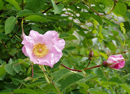
As we descend, we're engulfed in increasingly thick green underbrush, with sweet early summer wildflowers alongside the trail.


Bunchberry dogwood

Wild rhododendron
To complete the loop, there are a few junctions along the way. We didn't bring a map, but it's pretty easy to figure out we're not going all the way down to Multnomah Falls today (but would love to do that 6.8-mile hike some day). At the first junction about 2 miles along, we take the Multnomah Creek Way Trail #444.

Not far beyond the junction we come to an old log bridge over a boggy creek and stop to swig some water and enjoy the lush, profusely green forest around us. At the junction just past the bridge, we stay right on Trail #444.


 A little ways on we pass the one open area of the whole hike, an almost-filled in lake which apparently is deep in the old crater. Then we meander along the trail with a few ups and downs through what feels like an enchanted forest.  I tell Colleen I truly feel nourished by walking through a healthy forest like this, and she enthusiastically agrees.


Nurse log
After another mile or so, part of which follows a fairly flat old logging railroad grade, we go right at the Oneonta Trail #424 for the last mile back up to the road. We've seen just three other groups of hikers this morning, which I consider pretty good so close to Portland.


On the last stretch up through the forest, we pass huge old stumps along the trail with vine maples and other shrubs sprouting out of the tops, like so many mega-sized green bouquets. Most of the mountain was logged off in the early 20th century, although old growth remains in parts of the crater.


And suddenly the trail dumps us onto the road, where we walk up the last 3/10 mile to the car.  Even though it's socked in up here today, we still dash up and down the paved trail to the small summit lookout at Sherrard Point, an old basalt lava plug.

Views not so much today

Looking down from viewpoint


By the time we leave, the parking lot has started to fill up, despite the clouds and lack of views.  Of course, any Northwesterner knows, often the best time to be outdoors  is NOT on the bluebird days (which we do love too). 

Maybe next time we do a car shuttle and hike down to Multnomah Falls. But on a day enshrouded in clouds and mist, a hike through the emerald green forest up here at Larch Mountain with old friends/now new friends was just perfect.

Have you hiked this trail or down to Multnomah Falls from Larch Mountain? Would love to hear about your trip or other favorite hikes in Comments below. Happy trails and thanks for visiting Pacific Northwest Seasons.

When You Go
For particulars, a map, and directions to Larch Mountain, click here. Larch Mountain and the trail system is within the Columbia Gorge National Scenic Area, and a Northwest Forest Pass or $5 fee is required to park. The road to Larch Mountain is only open during the summer and fall and generally closes by November. This year the road opened in late May.


Thursday, June 12, 2014

Hiking the Mountains to Sound Greenway: Marvelous Mt. Washington

With ever increasing numbers of happy hikers hitting the trails near Seattle, somewhere off the beaten path was our goal for a weekend hike. While local hiking guides declare Mt. Washington, with its unmarked trailhead and confusing junctions, as lesser traveled, I'm here to say...on a sunny Sunday, this hike is definitely discovered. Think overflow parking.

Nevertheless, it's a lovely hike with splendid views from the top. And there are fewer crowds on the trail than across the Snoqualmie Valley at Mt. Si and Little Si or nearby Rattlesnake Ledge.

Write-ups about Mt. Washington vary wildly in the distances for this hike, from  5.5 and/or 6.5 miles according to the Washington Trails Association (they contradict themselves) to 12 miles according to SummitPost.org.  My quads and knees told me about 8 miles round trip with an elevation gain of about 3,400 feet.


On an early June weekend, we start up the not-too-grueling but steady trail  through dense, lush second-growth forest on the lower mountain under a cover of low-lying clouds. (There's a trick to getting to the trailhead, but more about that below under When You Go.)

While there aren't views for much of the lower portion of the hike, at about 2 miles we stop for a view across the valley at the Owl Bench, tucked against one of the numerous rock walls along the route. With the clouds we can't see anything but white mist.

Owl Bench

A little ways farther we cross another clearing beneath a talus slope in a cleft of the mountain. We've ascended into the clouds by now and the view of misty forest, while I think enchanting, isn't panoramic.


After more than 90 minutes of hiking and still being in the woods, the two 11-year-olds in our group are getting hungry and tired (or more likely bored because they can run circles around us adults on the soccer field). So we plop down for lunch at a nondescript spot on the trail. 

Replenished, we continue on because descending hikers keep telling us about the glorious sunshine above.  Along the way I can't resist taking a few shots of the many lovely trilliums alongside the trail.


After about 3 miles we finally emerge from forest and clouds and begin traversing rocky scree/talus slopes and more scrubby alpine forest. Another half mile or so and we finally reach....an old logging/service road. 

I always get slightly peeved when I see someone can drive up what I've labored to achieve. But these days the only use of the road, if at all, is to service the cell tower at the summit. 

So we cross the road and push up another quarter mile or so to the top. Where, it appears, we're floating on an island above the clouds, amongst other snow-capped and craggy islands.


Mailbox Peak


A little rocky outcrop in a meadow area at the last switchback to the top is actually a much nicer place to stop, with splendid views of Mt. Rainer to the south. The summit above is another rock outcrop, but views are partially obscured by trees.

Rainier above the clouds.

 So we enjoy the sun, take lots of pictures, snack, and head down just as the cloud-sea starts dissipating.


Those 11-year-olds?  They chose to hang out at the wetland below and are radioing every few minutes impatiently asking when we'll be back down. When we do get back, they feign nonchalance about missing the visual feast on top. Or maybe they truly don't care. I don't know, it has been too long since I was 11.

On the way down, I notice a cave I missed on the way up that's a popular rock-climbing spot. If we didn't have two girls desperate for our post-hike ice cream stop at Scott's Dairy Freeze in North Bend, I'd have stayed and watch what this guy does.


 More people are coming up as we descend, and when we get back to the parking lot, it's full with overflow parking onto the access road. And a line at the bathroom, where I find myself standing in line behind the same woman who was in front of me in the same line 4 hours earlier.

Small world, huh?

Overall I give this hike two thumbs up. Good exercise, good views, gorgeous forest, interesting rocks and walls, and not as crowded as other nearby well-trod trails.

Have you done this hike? Would love to hear how it was for you or about your favorite hikes in the comments below.  Happy trails and thanks for visiting Pacific Northwest Seasons!

When You Go
To get to Mt. Washington from Seattle, drive east on I-90 to exit 38. Head south (right), immediately crossing the South Fork Snoqualmie River, and take the first right turn into Ollalie State Park, a few hundred feet from the highway. Follow the gravel road to the end, parking near the bathrooms at the end of the lot.


Start at the short spur trail up to the John Wayne Trail/Iron Horse Trail near the end of the parking lot by the bathroom. Stay right at the junction, continuing to climb uphill for another tenth of a mile, and stay right at the next junction with the John Wayne/Iron Horse Trail—a wide gravel road. In a few hundred feet, head south on the second trail into the forest, 0.3 mile from the trailhead, marked by a small rock cairn, the start of the Mount Washington Trail. True, there are several junctions along the trail, but I didn't they were confusing.