Thursday, October 31, 2013

Hiking Beckler Peak: Ahhhsome Views

Time is running short for alpine-elevation hikes this season in the Northwest, so sneak out soon if you can for some thigh-burning and glorious views.  A couple days ago I hiked up Beckler Peak just east of Skykomish, Washington, for the first time. Wow.

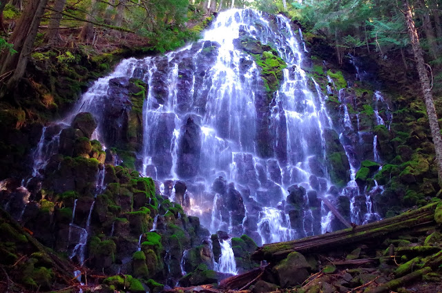
The stunning 360 panorama of jagged peaks and deep forested valleys was worth every drop of sweat. 

Two miles beyond the Skykomish Ranger Station we turn off State Route 2 onto Forest Service Road 6066 (well-signed) and continue 6.6 miles on dirt road up to the trailhead at 2,800 feet. Officially the Jennifer Dunn Trail, named after former Congresswoman Dunn who co-sponsored the Wild Sky bill designating Washington's newest Wilderness Area, the trail starts up old logging road through a recovering clearcut area.

This is the least scenic part of the hike (about a mile), but it's still nice to be outside in the woods.

  
After hiking about 45 minutes, we finally reach a clearing of old downed timber where the view south down and across the Skykomish Valley gives us a taste of what's to come.


Soon we plunge into a lovely forest, where the trail smooths out and angles gently upward through old growth silver fir.  For the next 45 minutes or so we meander upward through sun-dappled forest until we reach a few patches of snow left over from our late September snowfall.


Since it's a weekday (one of the benefits of self-employment), we only see a solo man and then two women and their fluffy cute dogs coming down as we're ascending.

"You're only about 10 minutes from the summit," says one of the friendly women.  

Note to self (and you):  Take the estimates of people you meet on the trail with a grain of sea salt.  For us it was another 20 to 25 minutes up increasingly short and steep switchbacks. 

Stone steps on the trail just below the summit.

But like I said, worth the effort when we scrambled over granite boulders to the top.


Beckler Peak summit, looking east

We're the only ones here right now, which is a good thing because there's not a lot of room at the tippy top.  And the peak, which is technically East Beckler Peak and part of a dramatic granite ridge, drops off steeply to the north. A long way....

Despite the brilliant autumn sun, there's a chill in the breeze up here. So I throw on my fleece vest and start taking pictures.

View westward along ridge to West Beckler Peak, Mt. Index and Baring beyond.

 
Monte Cristo peaks, north-northwest

Glacier Peak, Washington's least-known volcano, view northeast.
Mt. Fernow to the east.
View south, Mt. Daniel and Hinman (I think!).


After a snack and lots of picture-taking, we start down, which is always easier on the lungs but harder on the knees and toes. The views are still awesome for the first few switchbacks until we drop back into the forest.


On the way down several more groups and solo hikers are coming up, but it's still much less traffic than it would be on a weekend day.  Many of us outdoorsy types who live near the Salish Sea (Puget Sound and northward) know each other even though several million live in the region, and I bump into someone I know on the way down the trail. This often happens, actually.

Soon the snows will fly, likely making this summit inaccessible until next summer.  I'm so glad we got out for what might be one of the last great days of the year for peak bagging in the Cascades and Olympics.   I hope you can, too.

I learned about this hike through someone I just met last weekend who raved about it. Big thanks to Jim!  

Happy trails!

When You Go

Happy just below Beckler Peak summit.
The hike to Beckler Peak from the trailhead is 7.4 miles roundtrip over well-maintained and not too arduous trail. The summit is at 5,063 feet, with an elevation gain of 2,263 feet. Very doable for anyone in decent shape. Watch out for some big potholes on the last mile or so of the road before the trailhead as you climb. The restroom at the trailhead is now closed for the season.  A Northwest Forest Pass is required for parking here. Maps for this hike are the Green Trails: Skykomish #175 and the USGS Skykomish map.

For lots more photos and Northwest news between blog posts, Like the Pacific Northwest Seasons page on FaceBook or follow us on Twitter.


Friday, October 25, 2013

Seattle Japanese Garden: Fleeting Fall Brilliance

We're having a particularly beautiful autumn in the Pacific Northwest this year. Misty mornings burn off to luminous late afternoon sunshine, highlighting vivid fall colors. Nowhere is this more enchanting than in our local Japanese gardens, filled with exquisite maples that peak with brilliance each October.

These Japanese gardens, which reflect the historically strong Pacific Rim influence of Japanese culture here, are the epitome of the eighteenth century Japanese concept of mono no aware: the transient nature of beauty and life in general.

According to mono no aware, a falling or wilting autumn flower is more beautiful than one in full bloom precisely because we are aware of its fleeting nature.


I was just at the Seattle Japanese Garden at the southern end of the Washington Park Arboretum this week. (Interestingly, the even more mature, large, and sumptuous Portland Japanese Garden is also in Washington Park--in Portland.) I couldn't stop ahhhing at the loveliness in front of me.


As I wandered the pathways that wind through exquisitely landscaped grounds, my hands became chilled because I couldn't put away my camera.


I've pondered how much my compulsion to take photographs interferes with actually experiencing and appreciating the splendor of what's in front me at the time. I've decided that it just makes me appreciate things a bit differently. But the photos prolong my appreciation and preserves this spectacular autumn display.


The colors are at their peak this week, right now.  This tremendous local beauty is fleeting, so go today, tomorrow, or within a week at the most if you can.

And come back and leave a comment telling me about it!

When You Go
The Seattle Japanese Gardens are open Tuesday through Sunday from 10 am to 5 pm until November 2, then 10 am until 4 pm through November 30, when the gardens close for the winter. Get there early on weekends so you can find a place in the parking lot (like I didn't last Sunday). Entry fee is $6 for adults. Here's a map of how to find the gardens.  The Portland Japanese Garden is open seven days a week, 10 am until 4 pm. The Garden is located in the west hills of Portland, Oregon, directly above the International Rose Test Garden in Washington Park.

Also, Like the Pacific Northwest Seasons page on FaceBook for lots more photos and Northwest happenings between blog posts.

Monday, October 21, 2013

Great Northwest Fall Hikes: A Few Favorites

Before the snow flies in earnest here in the Pacific Northwest mountains, autumn offers some of the best hiking of the year. With patches of crimson and gold glowing on slopes and brisk mountain fresh air, fall in the Cascade and Olympic Mountains is my favorite time. 
There's something especially invigorating about hiking on the outer edge of winter, when sometimes you can even smell the coming snows. (Don't ask me what snow smells like, but it's fresh and cold and wintery.)

Here are a few of my favorite fall hikes with easily accessible trailheads.

Mt. Pilchuck
As I wrote a couple years ago, Mt. Pilchuck was the very first peak I ever climbed. Back then, when I was only 9, the mountainside on Pilchuck hadn't been clearcut all the way to the trail's edge.  But it's growing back nicely now.

Above the clouds, looking northwest from summit of Mt. Pilchuck.
 
I dashed up and down Pilchuck last weekend on a sunny but cool Sunday afternoon.  I went alone but ended up hiking with several other friendly hikers, including three from the East Coast who were visiting or recently moved here.


Pilchuck is a mere 20 miles east of Everett, Washington, and the Interstate 5 corridor on the Mountain Loop Scenic Byway, but it's a spectacular alpine hike with stunning views from the old fire lookout lashed to boulders at the summit. If you can, go during the week and avoid the weekend crowds.

This 6-mile hike gains a little over 2,200 feet in elevation over often rough and rocky trail.

Looking north from Pilchuck summit ridge.

Snow Lake
This extremely popular hike, which starts at the Alpental Ski Area parking lot at Snoqualmie Pass, is a favorite because it also delivers striking alpine beauty while being easy to access.  As with Mt. Pilchuck, go during a weekday if at all possible, or go very early on a weekend. At only about 50 miles southeast of Seattle right off Interstate 90, lots of urban hikers make the trip to the Pass for this hike.

Angle up a scenic valley past boulder fields until switchbacking up to a ridge with a great view down to Snow Lake.  Many hikers stop at the huge boulder atop the ridge for lunch and turn around, making it about a 6-mile (one source says 7-mile) roundtrip hike with an elevation gain of about 1,000 feet. 

Snow Lake


Descending the Snow Lake Trail in October.
Naches Peak Loop Trail
Another relatively easy but very scenic trail on the north edge of Mt. Rainier National Park is the Naches Peak Loop Trail at Chinook Pass just above Tipsoo Lake, along the Chinook Scenic Byway.  By mid-October the crowds should be dissipating although still likely heavy on a nice weekend day.

In October the low-lying shrubs on the hillside along the trail glow vivid scarlet.  And the view of Mt. Rainier is nothing less than magnificent. This loop is only 3.5 miles and gains a total of just 500 feet in elevation, although it starts at over 5,400 feet, so you might feel the altitude.

Along the way you'll pass a few lovely alpine lakes.


Colorful shrubs along the Naches Peak Loop Trail.


Mt. Rainier from Chinook Pass
Lake Ann, Maple Pass Loop off North Cascades Highway
While the North Cascades Highway closes each winter due to heavy snow and high avalanche potential, if you can sneak up soon before the snows really hit hard you'll be rewarded with views of golden larches and fabulous craggy peaks.

Liberty Bell from North Cascades Highway

There's already significant snow on the Maple Pass Loop trail, but hikers are out there doing it with their snow shoes or Yaxtrax strapped to their boots.  With dry weather predicted for another week or more, I say it's worth a trip out there, even if you don't make it all the way to the 7,000 foot high point on the trail. Heck, even a drive along the Cascade Loop is a fantastic day.

Looking down at Lake Ann along the Maple Pass Loop
Ramona Falls
It's been a long time since I hiked past Ramona Falls on the west side of Mt. Hood in Mt. Hood National Forest as part of backpack trip on the Timberline Trail.  But I have friends who just did this hike today in brilliant sunshine.

 
Image

I'm told the foliage is past its peak as of this writing, but it's still a lovely hike less than 50 miles east of Portland, Oregon.  You can make it a 7-mile loop with a gain of about 1,100 feet or continue on up to Yocum Ridge for a longer hike with spectacular close-up views of Mt. Hood.

I've just scratched the surface here (and partly wrote about hikes that I have photos to accompany).  Many more come to mind, like Granite Mountain just west of Snoqualmie Pass (and Bandera Mountain/Mt. Defiance/Mason Lake along the Ira Spring Memorial Trail that I just blogged about).

These hikes are all popular and easily accessed. There are also many great less known, longer hikes out there, too. For a longer, more remote trailhead hike, a friend just hiked up Carne Mountain north of Lake Wenatchee this past weekend, with golden larches and snow.  As one said, this is an Oh My God hike for its splendor.

 To find more hikes, try the Washington Trails Association or PortlandHiker.org websites.

What are you favorite autumn hikes in the Pacific Northwest? What have you done recently? We'd love to read your comments below.

For lots of Pacific Northwest Seasons photos and news between blog posts, Like our page on Facebook!


Tuesday, October 8, 2013

Hiking to Mason Lake: Spectacular Views and Fall Color

With its southern exposure, the Ira Spring Trail to Mason Lake and Bandera Mountain is a perfect place to hike magnificent alpine scenery early and late each year when snow lingers elsewhere.
On a bluebird fall day when the vine maples are near their peak of scarlet brilliance, this trail just west of Snoqualmie Pass near Seattle is especially stunning. When it emerges above the forest into the open slopes below Bandera Mountain, the boulder-strewn mountainside above is splashed with patches of crimson, orange, gold, and forest green.

We luck on such a day this past weekend when a hike to Lake Ingalls was cancelled due to heavy snow on the trail. So we miss the golden larches, but we get a stellar display of vine maples and other shrubs instead. I say that's a decent trade-off.

Besides all that fall color, there are stunning panoramas of Mt. Rainier to the south and  the Olympic Mountains farther to the weststriking reminders of our active regional geology here in the Pacific Northwest.


Mt. Rainier looms large to the south from the Ira Spring Trail.

Of course we're not alone on a beautiful day when there's snow at most of the higher alpine trails in the Cascades.  After driving a few miles off I-90 on a dirt road and dodging some impressive potholes, we manage to find a parking space at the outer edge of the parking area. Get here fairly early on weekends to find a spot; otherwise you'll be parking a ways down the road.

While the first mile or so is an easy stroll through forest along an old road grade, the trail steepens when it loses the road and switchbacks upward.

Treading gingerly across Mason Creek
I keep asking my hiking buddy Julie, who hiked here more recently, if each boulder field we cross that windows onto the valley below is "the" boulder field she says is ahead.

"Not yet." she replies.

Looking west down upper Snoqualmie Valley and I-90 corridor.


Based on the heavy snow last week (skiing at Crystal Mountain even!), I dressed for cool weather and packed a thermos of hot tea.  When we do break out of the forest into the upper boulder fields, I shed as many layers as possible and gaze in envy at others on the trail in shorts and T-shirts. 


At 2.8 miles along and well into spectacu-land, we reach a junction with a sign for Mason Lake (left) or Bandera Mountain (right).  I'm very tempted to continue up to the mountaintop for even better views, but today we're both feeling a bit rusty and stick with the original plan:  Mason Lake. So we head left.


The road not taken:  upward to Bandera Mountain summit
We angle a quarter mile up to the ridgetop and then drop down about 300 to 500 feet in elevation (sources differ) through forest to Mason Lake. We share the trail with Chris, a friendly medic who volunteers for the U.S. Forest Service and knows the trails around here well. (Big kudos to Chris and others who donate their time and expertise helping rescue lost and injured hikers.)


Nearing the ridgetop, Mt. Defiance summit just beyond


As we drop down behind the ridge, we enter a different ecosystem of moss and fungi compared to the sun-drenched southern exposure on the other side. 

 After finding a spot on a big boulder to park beside the lake, we relax for a while at this lovely alpine cirque. Reflected sunlight sparkles like diamonds flung across the dappled water surface, and it feels a world away from Seattle just 50 miles west. 


Bandera Mountain's snow-dusted summit rises high above the opposite lakeshore, where I spot a few hikers way up there.


On our way back down, we pause to drink in the view at the ridgeline above Mason Lake.  If we're lucky, we'll have more glorious fall days like this for hiking, but the odds are against another warm day like today in October.


As we're descending, trail runners pass us along with clumps of students from the University of Washington, members of a climbing club who've just descended Mt. Defiance beyond Mason Lake as a training hike. I used to feel the need for speed when hiking, but these days I try to savor the experience unless I'm racing the weather or darkness. 


This is a hike worth savoring.

When You Go              
According to the Washington Trails Association, it's a 6-mile round trip to Mason Lake from the trailhead, with an elevation gain to the ridge top of 2,550 feet. You gain another few hundred feet when you hike back up from the lake.  This an easy-medium hike; it starts out very mellow along the old roadbed but does get a little steep on a few of the switchbacks. However, the trail is very well-maintained, thanks to WTA volunteers. And of course it all depends on your conditioning. Don't forget your Northwest Forest Pass, which is required to park here.

Driving Directions                            
From Seattle drive east about 50 miles on I-90 to exit 45 (Forest Road 9030). Drive north, then stay left on FR 9030. About 1 mile from the freeway, you'll encounter a fork. Stay left again, now on Mason Lake Road (FR 9031). At about 3.9 miles from the freeway, park where the road is blocked--the road continues on the other side, but only for foot traffic. There is an outhouse at the trailhead, but bring your own TP just in case; there was no toilet paper when we were there a couple days ago.